

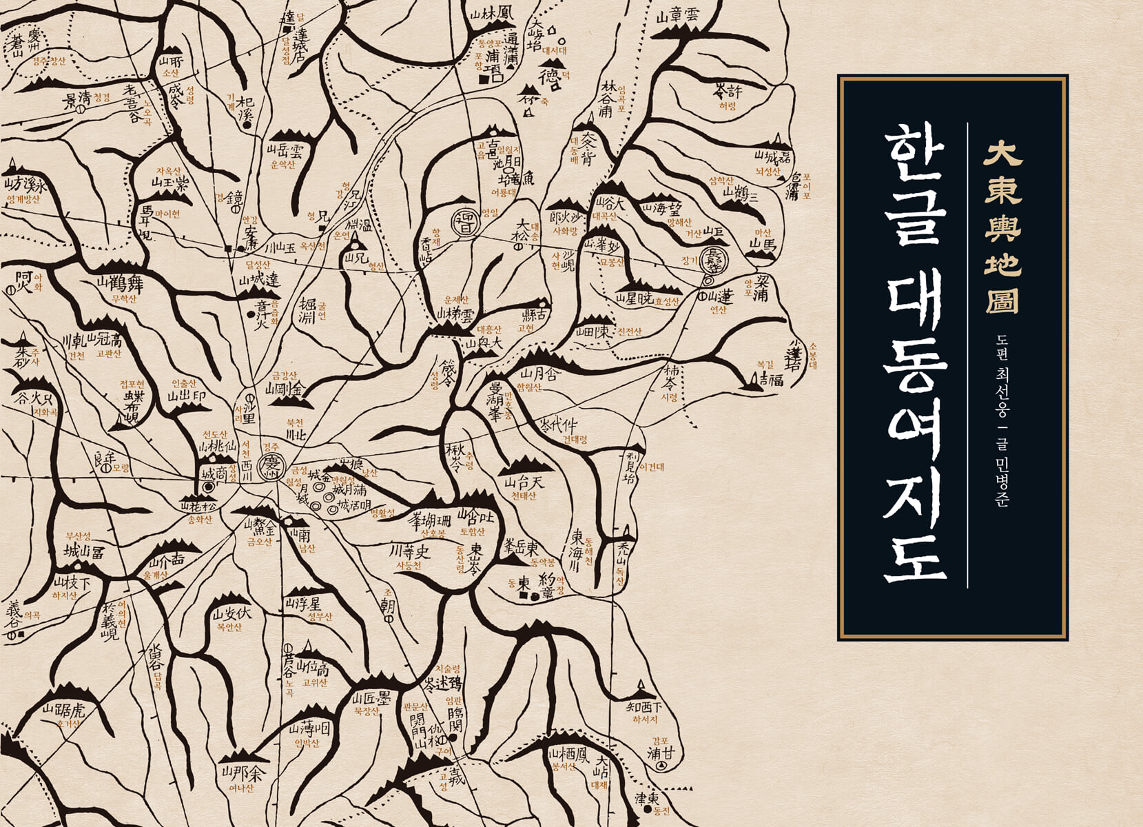
Korean Daedongyeojido
 |
Description
Book Introduction
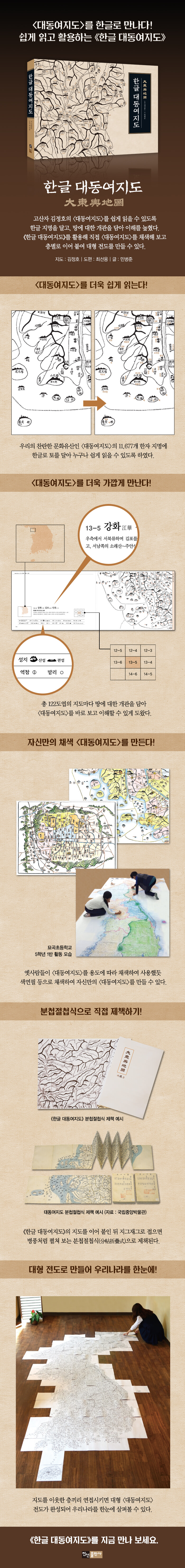
A book that makes the Daedongyeojido map more accessible and accessible!
The Daedongyeojido, which contained all of the land's natural and human geographic information, including mountain ranges, streams, towns, and roads, made it easy to obtain geographical knowledge of the entire country. It was a groundbreaking map at the time because it was produced on woodblocks and could be widely distributed.
Additionally, the use of symbols made it easier to read maps, the scale could be determined using a scale chart, and distances could be calculated using points marked on the road.
When fully unfolded, the map is approximately 3.8 meters wide and 6.7 meters high, making it as large as a two-story building. However, when folded, it can be made into a book, making it easy to carry and store.
Because of these excellences, the Daedongyeojido is considered one of the best maps in history, but it was not easy to read because the expressions were different from modern maps and the place names were in Chinese characters.
The 『Daedongyeojido』 helped people to read and understand the map by adding Hangul names to all 11,677 Chinese character place names and providing an overview of the land on each map.
This book, which contains 122 maps from the 1861 Sinyubon (辛酉本) reduced to approximately 65% of the original woodblock print on Korean paper, allows you to encounter the Daedongyeojido (Great Map of Korea) of that time more vividly and closely.
- You can preview some of the book's contents.
Preview
index
Features and Structure of this Book
Characteristics of the Daedongyeojido
Reading the Daedongyeojido
Daedongyeojido index map
Doseongdo│Gyeongjo Obu Island│1-1 Hunryung·Anwon│1-2 Onseong·Jongseong·Gyeongwon│2-1 Gyeongheung·Nokdundo│2-2 Hoeryeong·Haengyeong│2-3 Musan│2-4 Baekdusan·Cheonpyeong│2-5 Yeoyeon│2-6 Junggangdong Gupyeong│3-1 Daechodo·Sinjin│3-2 Puryeong·Eoyugan│3-3 Samsan·Yeonmyeon│3-4 Hyesan·Samji│3-5 Huju·Jangjin River│3-6 Muchang│3-7 Jaseong│4-1 Gyeongseong│4-2 Jangbaeksan│4-3 Gapsan│4-4 Samsu│4-5 Uhangnyeong│4-6 Manpo│4-7 Gueup│5-1 Myeongcheon│5-2 Gilju│5-3 Seongdaesan│5-4 Byeongpungpa│5-5 Jangjin│5-6 Ganggye│5-7 Wiwon·Chosan│6-1 Mayusan│6-2 Dancheon│6-3 Iwon·Bukcheong│6-4 Bujeonryeong│6-5 Nangrimsan│6-6 Jeokyuryeong│6-7 Byeokdong│6-8 Changseong│7-1 Mayangdo│7-2 Hamheung·Hongwon│7-3 Yeongseong│7-4 Huicheon│7-5 Unsan│7-6 Sakju·Guseong│7-7 Uiju│8-1 Jeongpyeong·Yeongheung│8-2 Yodeok│8-3 Deokcheon·Maengsan·Gaecheon│8-4 Yeongbyeon·Anju·Taecheon│8-5 Cheolsan·Seoncheon·Jeongju│8-6 Yongcheon│9-1 Gowon·Muncheon·Deokwon│9-2 Yangdeok│9-3 Eunsan·Seongcheon·Gangdong│9-4 Sukcheon·Yeongyu·Sunan│10-1 Munam│10-2 Anbyeon·Hoeyang·Tongcheon│10-3 Munseong·Bangjangchi│10-4 Samdeung·Sangwon·Suan│10-5 Pyeongyang·Gangseo·Hwangju│10-6 Gwangryang│11-1 Goseong│11-2 Geumgangsan·Geumseong│11-3 Icheon·Pyeonggang·Cheorwon│11-4 Singye·Seohung·Pyeongsan│11-5 Bongsan·Anak·Jaeryeong│11-6 Pungcheon·Jangyeon│12-1 Ganseong·Yangyang│12-2 Yanggu·Inje·Chuncheon│12-3 Yeoncheon·Yeongpyeong·Pocheon│12-4 Gaeseong·Jangdan·Baecheon│12-5 Haeju·Gangnyeong·Ongjin│12-6 Baekryeong·Haengyeong│13-1 Ugye│13-2 Gangneung·Pyeongchang│13-3 Hongcheon·Hoengseong│13-4 Hanyang·Gwangju·Yanggeun│13-5 Ganghwa·Gimpo·Incheon│13-6 Sanyeonpyeong│14-1 Ulleungdo·Usando│14-2 Samcheok│14-3 Jeongseon, Yeongwol, Yeongchun│14-4 Wonju, Jecheon, Chungju│14-5 Icheon, Yeoju, Anseong│14-6 Namyang, Dangjin, Myeoncheon│15-1 Uljin, Pyeonghae, Yeonghae│15-2 Yeongcheon, Yean, Andong│15-3 Goesan, Mungyeong, Boeun│15-4 Jincheon, Cheongju, Gongju│15-5 Seosan, Hongju, Boryeong│15-6 Anheung│16-1 Yeongdeok, Cheongha, Heunghae│16-2 Uiseong, Gunwi, Uiheung│16-3 Sangju, Seonsan, Yeongdong│16-4 Okcheon, Yeonsan, Iksan│16-5 Buyeo, Seocheon, Okgu│16-6 Eocheong│17-1 Yeongil, Janggi, Gyeongju│17-2 Yeongcheon, Daegu, Cheongdo│17-3 Seongju, Geochang, Hapcheon│17-4 Jinan·Jeonju·Imsil│17-5 Mangyeong·Buan·Gobu│18-1 Ulsan·Eonyang·Yangsan│18-2 Miryang·Gimhae·Changwon│18-3 Hamyang·Uiryeong·Jinju│18-4 Namwon·Gurye·Damyang│18-5 Gochang·Yeonggwang·Gwangju│18-6 Jido·Imjado│19-1 Dongrae│19-2 Ungcheon·Jinhae·Goseong│19-3 Sacheon·Gonyang·Namhae│19-4 Suncheon·Nakan·Boseong│19-5 Naju·Yeongam·Jangheung│19-6 Dakyeongpo·Heuksando│20-1 Geoje│20-2 Geumsan·Dolsando│20-3 Heungyang│20-4 Haenam·Wando│20-5 Jindo│21 Chujado│22 Jeju·Jeongui·Daejeong
Using the Daedongyeojido in Hangul
Detailed image
Publisher's Review
Create your own colored Daedongyeojido!
The Daedongyeojido is a map carved on a woodblock, and the final product is a paper map printed with ink.
Therefore, the mountain ranges, watercourses, county boundaries, roads, and various symbols on the map are all written in ink, making it difficult to read the map right away.
Even at that time, map users used black and white maps printed on woodblocks and colored them according to their intended use.
When comparing the colored copies of the Daedongyeojido stored at the Kyujanggak Institute for Korean Studies at Seoul National University and the Yenching Library at Harvard University in the United States, the coloring methods for land, water, boundaries, roads, and symbols are different.
Let's open the map of the area where I currently live in 『Hangeul Daedongyeojido』 or the city map showing the inside of the Hanyang fortress walls and color it with colored pencils or paints.
By coloring all the symbols on the map, including land, sea, rivers, county and district boundaries, roads, townships and beacons, post stations and royal tombs, you can create your own colored Daedongyeojido.
Through the process of coloring the map in this way, the Daedongyeojido, which had previously only been seen in black and white, began to appear three-dimensional, allowing the geography of the region to be read and understood directly.
Let's make a book and a large-scale evangelism book ourselves!
『Hangeul Daedongyeojido』 is a book that contains 122 maps of the Daedongyeojido in reduced form, and is composed of a total of 22 layers, just like the Daedongyeojido.
The book is bound in a zigzag-fold style, where each map leaf is separated from the book, each layer is pasted together, and then folded in a zigzag pattern so that it can be unfolded like a folding screen.
Also, let's unfold the map bound in a folded book and connect the adjacent layers.
If all the maps of the Hangul Daedongyeojido, which are reduced to about 65% of the size of the Daedongyeojido, are connected, a large-scale Daedongyeojido map measuring 2m 44cm wide and 4m 14cm high is completed, allowing us to see our country at a glance.
Features of this book
1.
Korean notation miniature version of the Daedongyeojido
In 1861, the 122 map leaves of the Sinyubon (辛酉本) Daedongyeojido were each reduced to about 65% of their original size, and all place names and periods were written in Hangul.
2.
Add Dokdo and Geomundo
Usando (于山島) and Samdo (三島) of Geomundo, which were not marked on the Daedongyeojido, were added to the map, and incorrect place names were corrected to the extent possible.
3.
Coloring the Daedongyeojido
Just as people who used paper maps printed with ink colored them according to their intended use, you can create your own colored Daedongyeojido by coloring it yourself with colored pencils or paints.
4.
Making a book by binding it in a bookbinding style
The Daedongyeojido can be bound in a book using the folding method (分帖折疊式), where each layer is attached and then folded in a zigzag pattern to unfold it like a folding screen. If adjacent layers are connected, a large-scale map can be completed, allowing a view of Korea at a glance.
GOODS SPECIFICS
- Date of issue: September 9, 2025
- Page count, weight, size: 252 pages | 816g | 260*187*19mm
- ISBN13: 9791193003848
- ISBN10: 1193003849
You may also like
카테고리
korean


korean

![GQ KOREA Mark (Monthly): December [2025]](http://librairie.coreenne.fr/cdn/shop/files/8ef265dbbfbf186523ed75ba7319009d.jpg?v=1765340328&width=3840)


