

Jirisan Dulle-gil
 |
Description
Book Introduction
The official guidebook created by the Forest Trail Association, which creates and manages the Jirisan Trail.
It also contains information on walking tours along the Jirisan Mountain Trail and rich commentary on the nature and culture of the Jirisan area.
It's full of practical information for hikers, including elevation charts, guide maps, and public transportation.
A portable, large-format map summarizes the information contained in the book along with the course guide, making it useful for walking the Jirisan Trail.
- You can preview some of the book's contents.
Preview
index
Opening remarks
Recommended articles
Note
Jirisan Trail Opens
Opening poem
Jucheon~Unbong
Unbong~Inwol
Road and Story 1
Inwol~Geumgye
Geumgye~Donggang
Road and Story 2
Donggang~Sucheol
Sucheol~Seongsimwon
Road and Story 3
Seongsimwon~Unri
Unri~Deoksan
Road and Story 4
Deoksan~Witae
Dangerous~Ha Dong-ho
Road and Story 5
Hadongho~Samhwasil
Samhwasil~Daechuk
Road and Story 6
Hadong-eup~Seodang
Daechuk~Wonbuchun
Wonbuchun~Gatan
Road and Story 7
Gatan~Songjeong
Mokajae~Dangjae
Songjeong~Omi
Omi~ chaos
Road and Story 8
Omi~bladder
Bladder~Shandong
Road and Story 9
Shandong~Zhuchuan
Road and Story 10
Detailed image

Publisher's Review
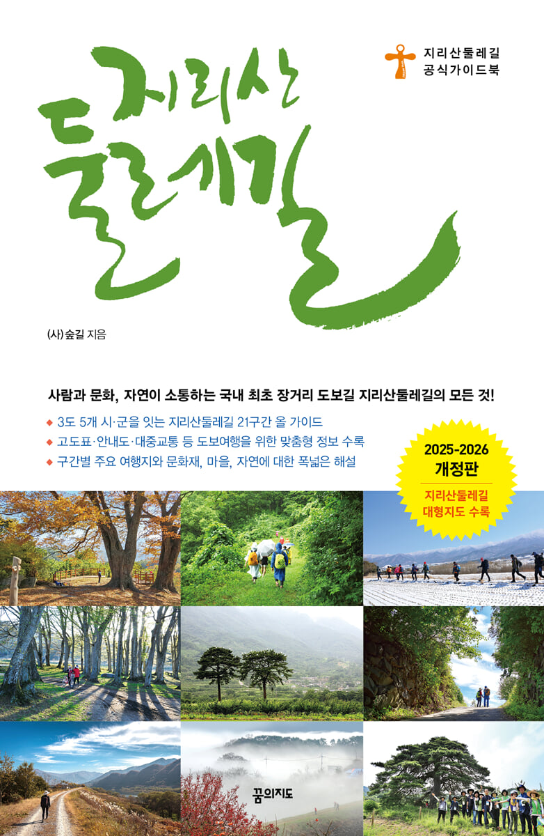
A guidebook for Korea's first long-distance hiking trail, the Jirisan Dulle-gil!
All-in-one guide to the 21 sections of the Jirisan Dulle-gil hiking trail connecting 3 provinces and 5 cities and counties!
Includes customized information for walking tours, including elevation charts, guide maps, and public transportation!
Jirisan Dulle-gil is the origin of the new standard for hiking trails.
The Jirisan Trail, which was created in 2004 at the suggestion of pilgrims who set out on the path to Jirisan with the motto of “Life and Peace,” has become the seed of hiking and has spread throughout the country.
After that, numerous trails were created, starting with the Jirisan Trail.
Jirisan Dulle-gil is a trail that goes around Jirisan Mountain.
We make a pilgrimage to Jirisan Mountain, crossing hills, passing through forest paths, and connecting villages.
It connects approximately 100 villages across three provinces (Jeonnam, Jeonbuk, Gyeongnam) and five cities and counties (Gurye, Namwon, Hamyang, Sancheong, and Hadong).
If the Jirisan mountain trail is a dream for hikers, completing the Jirisan trail is a dream for hikers.
There are many trails, but the Jirisan Trail is by far the best in terms of symbolism, satisfaction, and sense of accomplishment.
That is why Jirisan is called the 'number one hiking destination' for hikers.
Jirisan Dulle-gil is an official guidebook published by the Forest Road Association, which develops and manages the Jirisan Dulle-gil.
A revised edition with newly refined and structured courses and updated information.
The Jirisan Trail, which opened its entire section in May 2012, has undergone major and minor changes to its course since then.
There are some new paths added, and some that were originally included but have been removed.
Additionally, even after the entire section opened, there were some errors and inaccuracies in distances and information.
The 2025-2026 revised edition also includes revised course distances and elevation charts that were newly confirmed through actual measurements.
The official guidebook of the Forest Trail Association, which manages and operates the Jirisan Trail.
The Forest Road Association is an organization that builds and manages the Jirisan Trail.
It was launched in 2007 to continue the Jirisan pilgrimage route proposed by the Life and Peace Pilgrimage Group in 2004 and to promote a prosperous life on Jirisan.
The Forest Road Association knows better than anyone that connecting the Jirisan Trail is connecting the hearts of the people who live along the trail.
The Jirisan Trail tour that the Forest Road Association envisions is a journey where travelers and local residents can come together to create a happy, self-reliant community in Jirisan without damaging the foothills of Jirisan.
With this in mind, an official guidebook was created to enable travelers to walk the Jirisan Trail on their own.
This guidebook is filled with accurate information and rich stories about the journey.
Rather than simply walking along the road, we guide you to see and feel the various sights of the foothills of Jirisan.
As you follow the path guided by the Forest Road Association, you will soon find yourself listening to the forest and the village.
Reliable travel information on accommodations, transportation, and restrooms essential for your Jirisan Trail trip!
Even a hiking trip with just a light backpack requires preparation.
First, you need to find a path that suits you, your family, and your colleagues.
This book provides an experience of walking the section in advance by viewing the section at a glance and viewing the section in detail.
This will help you find the right section.
Next are the problems of transportation and accommodation.
This book provides detailed information on each course, including destinations and taxi numbers.
It also includes essential information for hiking, including distance, altitude, difficulty, and restrooms.
This guidebook was created directly by the organization that created and manages the Jirisan Trail, so it is 100% trustworthy.
Includes a large portable map that provides information on the Jirisan Trail at a glance!
The Jirisan Trail Guidebook includes a large map of the Jirisan Trail as a separate appendix.
A large portable map allows you to see the entire Jirisan Trail course at a glance.
The distances and major travel points for each course are marked, so you can walk the perimeter trail just by looking at the map.
Additionally, it contains essential information such as distance and estimated time for each section, major stopovers for each section, transportation, oil field information, and emergency contact information for buses and taxis.
When walking the Jirisan Trail, you can leave the book behind and just take a large portable map.
GOODS SPECIFICS
- Date of issue: May 10, 2025
- Page count, weight, size: 248 pages | 396g | 137*210*13mm
- ISBN13: 9791167621160
- ISBN10: 1167621166
You may also like
카테고리
korean


korean

![GQ KOREA Mark (Monthly): December [2025]](http://librairie.coreenne.fr/cdn/shop/files/8ef265dbbfbf186523ed75ba7319009d.jpg?v=1765340328&width=3840)


