

Seoul, a city you can see on foot
 |
Description
Book Introduction
"Seoul, a City Visible on Foot" presents the time and space of Seoul captured through drawings while walking. By introducing the layers of modern and contemporary history in familiar places in the city center and alleyways, centered around Seoul Station, we rediscover the humanistic value of the urban spaces around us. This is a 'Seoul Humanities Walk + Drawing Essay' where you can experience the beauty of these places anew through sketches and drawings that provide visual pleasure, and witness the identity of time and space layered throughout the route. This book presents seven different Seoul city walking routes for those seeking alternative travel options in the "With Corona" era. The refreshing illustrations depicting major urban spaces along the route capture the reader's eyes, drawing new attention to places that we often pass by but never pay attention to. This humanistic city walk, presented by the author with a keen eye for space, architecture, and cities, will provide an opportunity to indirectly experience Seoul's modern and contemporary lifestyle and cultural history and rediscover "what kind of place is my city?" |
- You can preview some of the book's contents.
Preview
index
Prologue_ The Beginning of City Walking
[Part 1] East Side of Seoul Station: Downtown and Namsan
[First Walk] The layers of modern and contemporary architecture in harmony with red bricks
: Seosomun-dong, Jeong-dong area | Seohakdang-gil
[Second Walk] The Desire for Slow Life That Shakes Up a Neighborhood Where Time Has Stopped
: West side of Sejong-ro, Seochon area
[Third Walk] Beyond Gyeongseong's Hot Places, Modern Seoul's Subtle Monuments
: Namdaemun-ro, Myeongdong area | Cheonggyecheon Stream, Sewoon Shopping Center
[Fourth Walk] The Rise and Fall of Residential Areas at the Foot of Namsan, After the Japanese Occupation
: Dongja-dong, Huam-dong | Haebangchon
[Part 2] West Side of Seoul Station: Hills and Railroads
[Fifth Walk] A Home Behind Seoul Station, Nestled on a Hill
: Jungnim-dong, Chungjeong-ro | Ahyeon-dong, Hwanil-gil | Cheongpa-dong, Wonhyo-ro 1-ga
[Sixth Walk] The new flesh and sinews of the city that have taken root where the train left off
Saechang Pass, Dohwa-dong | Gyeongui Line Forest Trail, Wawoo Bridge | Traces of the Sinchon Line | University Village in front of Yonsei University
[Seventh Walk] Beneath the Crouching Mountain, the Smoke-Fired Chimney of the Cultural Power Plant
: Wawoosan Mountain, Hongik University Station | Danginri Line traces, in front of the power plant
Epilogue_ The End of City Walking
Resources that helped with writing
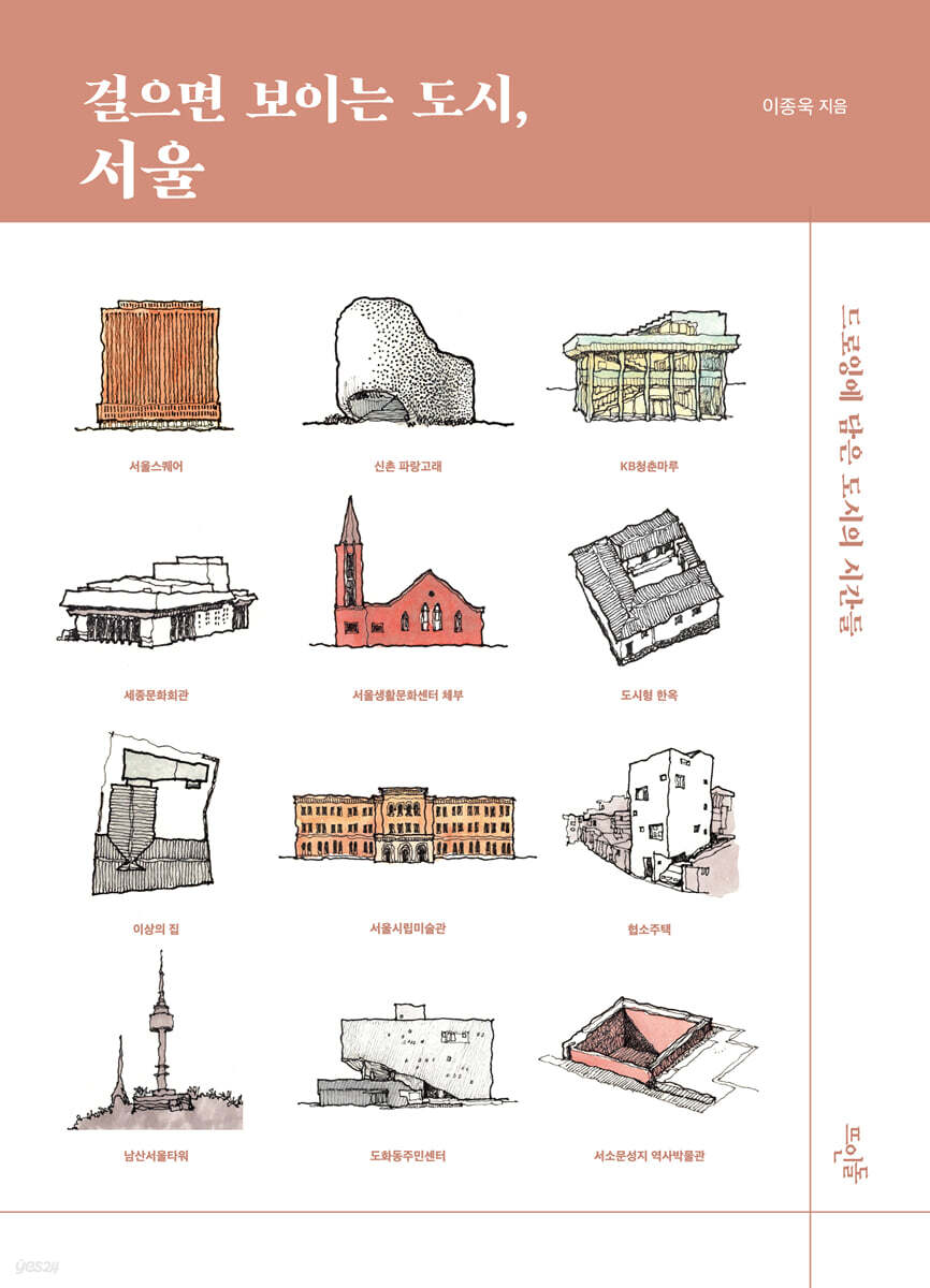
Detailed image
.jpg)
Into the book
The urban hanok is a so-called 'Jipjangsajib', which has the characteristics of a traditional hanok but was modified to fit the urban environment, and was much loved by the people of the time.
Most of the hanoks remaining in Seochon today are urban hanoks built at that time.
Considering that the quaint scenery of Seochon, which we love, is due to urban hanoks, it is possible that the majority of today's ordinary hanoks will also one day be re-evaluated.
--- p.89
I climbed up the old concrete stairs and onto ‘Kim Soo-geun’s Aerial Street.’
The rough and rugged landscape of the Seun Shopping Mall area stretched out endlessly.
It was surprising that such a ridiculous building had been built in such a place, and it was also surprising that anyone thought of completely turning this ridiculous place upside down.
The future of Seoul is one that is difficult to grasp.
I just timidly believe it.
Even though it may be a bit bumpy at a micro level, and there may be ups and downs, ultimately, we are moving in the right direction, towards a city that is a better place to live… … .
--- p.127
After liberation and the war, the most important value was survival.
I had to climb the stairs to get to a rickety shack where I could rest my weary body.
As living standards have improved, the quality of living environment has become an important value.
A flower bed was created in the middle of the stairs and trees were planted.
And today, as consideration and concern for the socially disadvantaged have become important values, inclined elevators have been installed on the stairs.
Standing before the 108 Heavenly Stairs, which were created by the values of an era that were not so easy, I feel a sense of solemnity.
Fortunately, as time passes, the stairs seem to be gradually imbued with human value.
It remains to be seen what values will change this staircase in the future.
--- p.151
Leaving Haebangchon, we look back at the Haebangchon hills from Noksapyeong-daero.
It is harmonious as if it were one giant building, and at the same time, it has an organic shape like a living organism.
In each and every wrinkle of that gigantic creature, the lives of countless people who passed through Haebangchon are meticulously recorded and stored, like the grooves of a record.
Some neighborhoods are on different paths of destiny: some are undergoing urban regeneration, while others are undergoing large-scale redevelopment.
Perhaps in less than ten years, some of my sketches will be so recognizable that it will be hard to even guess which neighborhood they are from.
--- p.161
If buildings have personalities, then the personality of the St. Joseph Apartment would be humility.
The virtue of humility is also found on the plane.
The apartments are also curved in the same way as the gently curving road to the south.
You might ask what's so great about a building following the shape of the land, but if you remember that modern apartment buildings built on slopes sit proudly on land that flattens the land and straightens the curved roads, you'll agree with me.
--- p.175
It is not easy to see the full face of a building from a narrow alley.
On the other hand, on curved and sloping roads, it is relatively easy to see the faces of buildings that are revealed at different angles.
Just as face-to-face conversations become more intimate, the more visible the facade of a building is, the more interesting it becomes to walk and focus on the space itself.
This may be why my steps on the Hwanilgil Road become more serious, unlike on other transit roads where I pass through in a hurry.
In the city, I want to walk a little more seriously.
--- p.193
Walking through the cherry blossom garden in full bloom in April feels like a reward for the long journey of suffering and adversity on the Yongsan Line.
When we look at the background and process that led to the creation of such a beautiful cherry blossom road in the middle of the city, it is nothing short of an irony of history.
In this way, the traces of imperialism imposed by Japan are being corrected little by little by the people of the Republic of Korea, even if it is a tumultuous process.
So, even amidst the dazzling bloom of cherry blossoms, even amidst the lively atmosphere of the bars and cafes lining the forest path, it is crucial to reflect on the history contained in this empty space.
Even the little things in daily life are not something that can be obtained for free.
--- p.246
Today, as I climbed up to the Wau Bridge again, the long green forest stretching on both sides of the bridge felt unfamiliar.
Not only the disappeared railroad tracks, but also the buildings that once turned their backs on the railroad tracks now show off their unique exteriors and interiors facing the park as if nothing had ever happened, giving off a sense of distance.
At the same time, I am amazed at how this place could become such a comfortable space and such a vibrant place.
Looking back, we can see once again that the empty spaces (voids) of the city can only shine brightly when they are filled with people.
--- p.251
The urban hanoks of Sinchon were nothing more than relics of the past that should be demolished as soon as possible, and nothing more than a bunch of rascals wasting precious land.
Eventually, most of the many urban hanoks were demolished, and now only a very small number remain.
If we look only at the trends of the past decade or so, when countless people flocked to Insa-dong, Samcheong-dong, Bukchon, Seochon, and Ikseon-dong, where urban hanoks are relatively well-preserved, it can be said that Sinchon has lost the opportunity to be re-evaluated as a commercial district with a vibrant local character.
Thinking about it differently, it also means that from the beginning, Sinchon was planned as a site of a fiercely capitalist market economy where there was no room for things like non-material values or leisure.
--- p.258
What would have happened if the Wawoo Apartments hadn't collapsed? Perhaps hilly areas like Haebangchon and Ahyeon-dong would have been densely packed with apartments for citizens, or perhaps other urban eyesores, even surpassing the Seun Shopping Center and Cheonggye Elevated Expressway, would have stood like monuments throughout Seoul.
Or, they could have just demolished all of this before Mayor Kim's term even ended and continued another construction myth.
It will undoubtedly look quite different from Seoul today, and urban scholars and architects will undoubtedly have more homework to do.
--- p.286
Why do architects, when discussing Seogyo 365, focus so much on the concept of memory?
Perhaps it is because of something that remains between the surfaces and cracks of concrete, steel, glass, and wood, even after all three elements of architecture—function, structure, and beauty—have been removed from this dilapidated group of buildings.
And it can be compressed into the concept of time, which encompasses everything from personal episodes to social, collective events and history.
Memory is like a medium that connects the abstract idea of time to the concrete and material architecture.
Although there is another irony that the artists and architects who saved Seogyo 365 were forced to leave the building because of the murderous rent, Seogyo 365 has been embodied in material form until that time.
I want to watch for a long time to see how long this collection of memories will last in Hongdae.
--- p.297~298
The history of Seoul Thermal Power Plant is closely related to the history of the neighborhoods we visited earlier.
The power plant, which was first built during the Japanese colonial period, came into our hands after liberation.
As we went through the development period, we expanded the power plant without much thought in the location designated by the Japanese, but soon realized that it was not a suitable location for the new era of Seoul.
In the 2000s, the city of Seoul began to worry about how to deal with the power plant.
While the city was debating the redevelopment method, real estate prices rose and gentrification occurred.
In any case, it was decided that the power plant would coexist with Seoul City.
I look forward to it cautiously.
I hope that the new chapter of history that will be written at the Seoul Thermal Power Plant will become a milestone that will suggest a long-term future for the neighborhoods surrounding the power plant and, by extension, for Seoul.
--- p.311
In today's world, with so many interesting and captivating things to do, it's easy to overlook the history of your city or neighborhood.
In times like this, I recommend just walking.
A relatively light and easy way to start a city walk will help you develop a love and interest in a place, and that love will extend to its history.
By learning about the history of a place in this way, things previously invisible will become visible, and such experiences will broaden the horizons of one's personal geography.
--- p.320~321
Publisher's Review
Reuniting Seoul through drawing,
A Cultural Tour of Seoul Through City Walking
The world, which had been at a standstill due to COVID-19, is slowly starting to open up.
However, experts predict that for a considerable period of time to come, travel to other countries will have to be done cautiously and encounters with people will inevitably be limited.
In this "with COVID" environment, where movement and gatherings remain challenging, why not consider taking a closer look at the urban spaces that have silently surrounded our lives? Here, a drawing essay rediscovers the urban patterns etched throughout the streets as we meticulously walk around.
"Seoul, a City Visible on Foot" presents the time and space of the city witnessed while walking through Seoul, through rich text and illustrations.
By revealing, layer by layer, the traces of modern and contemporary life and culture that exist in the city center and its surrounding streets, centered around Seoul Station, we rediscover the humanistic value of urban space.
This is a 'Seoul Humanities Walk + Drawing Essay' that rekindles the aesthetics of space through refreshing pictures, while exploring the identity of time and space layered throughout the route.
A place where life and time in Seoul are piled up,
Stroll through the city center and alleys of Seoul Station, east, west, south, and north.
The author, Jongwook Lee, is an architect who designs industrial facilities.
Separate from his professional activities, he has been personally surveying and sketching various places in Seoul for nearly ten years, continuing to record, reflect on, and interpret the city, architecture, and space.
Familiar spaces in the city that we pass by on a daily basis, places that we usually don't pay attention to or look into deeply.
The author observes the city's time, which has settled quietly within it, with a keen eye and cherishes it with a sensitive hand.
It presents the reader with a moment of rediscovery of the traces of time engraved in each and every pattern of the city.
This book presents seven routes for walking around Seoul.
The starting point of the walk is Seoul Station, which has long been the gateway and symbol of Seoul.
Part 1 consists of four routes: the east side of Seoul Station, the downtown area centered around Sungnyemun Gate, its surrounding areas, and the foothills of Namsan Mountain.
Next, we grouped three routes into two parts, following the wide hilly area west of Seoul Station and the traces of the old Gyeongui Line and its branch lines.
In terms of administrative districts, the routes in Part 1 correspond to parts of Jung-gu, Jongno-gu, and Yongsan-gu in Seoul, and the routes in Part 2 correspond to parts of Jung-gu, Yongsan-gu, Mapo-gu, and Seodaemun-gu.
The downtown area east of Seoul Station and the foot of Namsan Mountain
: Jeongdong, Seochon, Myeongdong, Euljiro, Huam-dong, Haebangchon
The walking routes in Part 1 were selected with a focus on temporality.
These routes vividly show the changes in Seoul's urban space, from the reorganization of the city center during the Japanese colonial period, the development period after liberation until the 1990s, and gentrification after the 2000s.
The first route, Jeong-dong and Seohakdang-gil, examines the background of the formation of the 'red brick' buildings that were built in the Jeong-dong area over 100 years ago, and the historical significance of the 'red brick' buildings built by Korean modern architects one after another on Seohakdang-gil in the 1970s and 1980s.
The second route, the west side of Sejong-ro and the Seochon area, examines how the underdeveloped commercial districts and quiet residential areas of the city center were disrupted by the new desires of the times after the 2000s.
The third and fourth routes unfold the story from the impact of the urban structure and organization formed during the Japanese colonial period on the formation of modern Seoul's streets.
At the beginning of the third route, in the Myeong-dong area, you can see modern architecture imbued with Japanese Orientalism, and at Cheonggyecheon, Euljiro, and Seun Shopping Mall, which are symbols of the development era, you can criticize the reckless dreams of development that were repeated not only in the 1960s and 1970s but also after the 2000s.
The fourth route, the area around Huam-dong and Haebangchon, examines the spatial characteristics formed after the Japanese shrine and cultural housing complex were built in this area.
In addition, we examine the vitality of the residential areas of the working class that rose up along the slopes of Namsan Mountain after liberation, and the shadow of gentrification that this area has also not been able to avoid in recent times.
The hills west of Seoul Station and traces of the old Gyeongui Line
: Jungnim, Ahyeon, Cheongpa-dong, Gyeongui Line Forest Road, Sinchon, Hongik University
The routes in Part 2 were selected based on the geographical features of hills and the infrastructure of the railway, which had a decisive influence on the formation of the urban structure.
These routes, which begin when you exit west of Seoul Station, also bear traces or scars of the Japanese colonial period, the development period, and the post-2000s era.
The fifth route begins by examining the living witnesses of Korean apartment history, seen in Jungnim-dong, Migeun-dong, and Chungjeong-ro.
Next, in Ahyeon-dong Hwanil-gil and Seogye-dong and Cheongpa-dong, the contrast between the low-rise residential areas that rise up the hills and the high-rise redevelopment districts that surround them is highlighted, and at the intersection of Wonhyo-ro, the interesting changes in the street structure of this area since the Japanese colonial period are introduced.
The sixth and seventh routes follow the railroad tracks.
First, the sixth route follows the Gyeongui Line Forest Trail.
After encountering the legacies of the 'modernization' and 'development' era of the 1960s and 1980s in the Dohwa-dong and Gongdeok-dong areas, the Gyeongui Line Forest Trail's Daeheung-Sinsu-dong section traces the history of the old Gyeongui Line (Yongsan Line)'s ordeals.
And we examine the landscape of the western side of Changcheon-dong created by the old Sinchon Line and the characteristics of the urban structure of the Sinchon area.
The last seventh route goes through Wau Mountain and the 'Hongik University' area.
We examine the unique street characteristics of this area, created by the old Danginri Line and the "Hongik University" phenomenon, and glimpse into the concerns and expectations for the future of Seoul's urban space through the ongoing transformation and alteration of this area.
Curious about my city? Just take a walk!
The author concludes his Seoul walk at the Jeoldusan Martyrs' Shrine.
In his early twenties, just starting out in Seoul, he took the bus across Yanghwa Bridge every morning to avoid the demolished Dangsan Bridge.
The beautiful Jeoldusan Martyrs' Shrine reflected in his eyes, the long power plant to its right, and the sight of Gangbyeonbuk-ro, lined with cars, were impressive images of this city that captured the attention of the freshman architecture student.
Of course, we too have a vague image of our own city.
But not many people can readily answer the question, “What kind of place is your city?”
This is because, despite the fact that I step foot in it every day, I have never tried to properly experience and observe ‘my city.’
The author advises:
“Just walk.”
Even a leisurely stroll through the city will help you develop a love and interest for a place, and that love will extend to its history.
By learning about the history of a place, you will be able to see things you never saw before.” An appreciation for the beauty of a city and space begins with the first step you take toward it.
We hope that through the humanistic city walk presented in "Seoul, a City Visible on Foot," you will experience the joy of discovering "what kind of place is my city?"
GOODS SPECIFICS
- Publication date: November 25, 2021
- Page count, weight, size: 328 pages | 680g | 166*230*20mm
- ISBN13: 9788958078791
- ISBN10: 8958078790
You may also like
카테고리
korean


korean

![ELLE 엘르 스페셜 에디션 A형 : 12월 [2025]](http://librairie.coreenne.fr/cdn/shop/files/b8e27a3de6c9538896439686c6b0e8fb.jpg?v=1766436872&width=3840)


