

Korean Topographic Atlas
 |
Description
Book Introduction
“Topographical studies have been a lifelong pursuit.”
The aesthetics of topography collected over 40 years!
Organizing and explaining 191 examples, ranging from weathered to arid terrain.
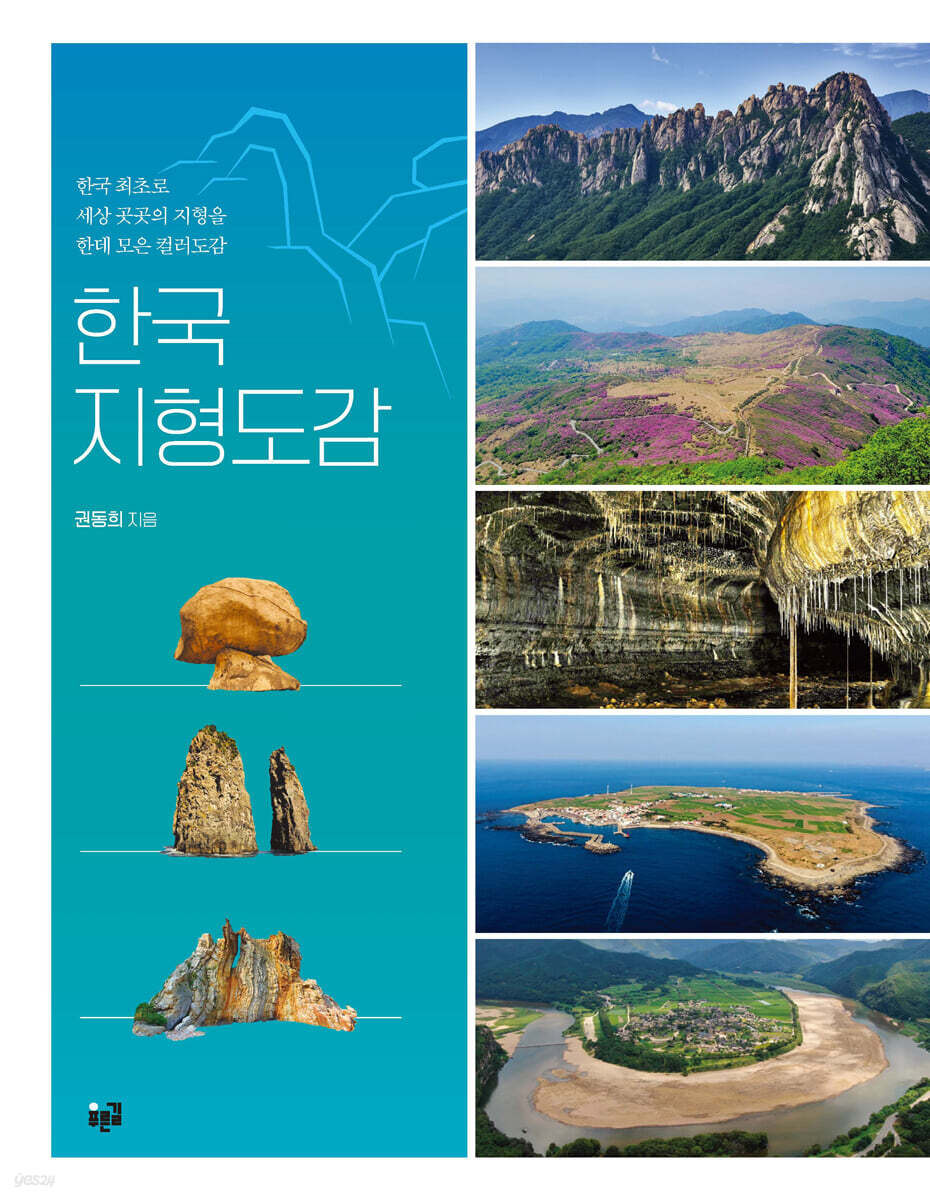
『Korean Topographic Atlas』, which organizes and explains the topography of Korea, has been published by Pureungil.
The author explains topographic information in an easy-to-understand way based on topographic photos taken while traveling around the country.
It contains detailed information on the topographical features and backgrounds of each region of the country, including not only weathered landforms but also mountains, plains, rivers, wetlands, coasts, karst, and volcanoes.
This book, which contains a rich collection of 191 topographical examples, is significant in that it is Korea's first topographical atlas.
The shape and characteristics of terrain vary depending on what kind of rock the soil layer is made of and what type of weathering and erosion it has experienced.
From wetlands developed by the flow of rivers, to sandbars and pools formed on the coast by waves and currents, to caves formed by the erosion of limestone, to volcanic bodies formed by the deposition of volcanic ash.
As each landform has a different name, it contains an infinite history of nature that cannot be known without looking closely.
The text is divided into 13 topics according to the universal subject classification method of geomorphology.
Although this is a Korean topographic map, some world topographic examples are also introduced in each chapter to help readers understand.
Although it does not exist in our country, it also includes glacial landforms and arid landforms, which are essential topics in geomorphology textbooks, to complete the book as a topographical atlas.
As we turn the pages of the book, following the author's fascinating explanations, we come to realize that topography does not simply mean land.
The process of understanding the terrain as an element that constitutes nature will soon lead to understanding nature itself.
The aesthetics of topography collected over 40 years!
Organizing and explaining 191 examples, ranging from weathered to arid terrain.
『Korean Topographic Atlas』, which organizes and explains the topography of Korea, has been published by Pureungil.
The author explains topographic information in an easy-to-understand way based on topographic photos taken while traveling around the country.
It contains detailed information on the topographical features and backgrounds of each region of the country, including not only weathered landforms but also mountains, plains, rivers, wetlands, coasts, karst, and volcanoes.
This book, which contains a rich collection of 191 topographical examples, is significant in that it is Korea's first topographical atlas.
The shape and characteristics of terrain vary depending on what kind of rock the soil layer is made of and what type of weathering and erosion it has experienced.
From wetlands developed by the flow of rivers, to sandbars and pools formed on the coast by waves and currents, to caves formed by the erosion of limestone, to volcanic bodies formed by the deposition of volcanic ash.
As each landform has a different name, it contains an infinite history of nature that cannot be known without looking closely.
The text is divided into 13 topics according to the universal subject classification method of geomorphology.
Although this is a Korean topographic map, some world topographic examples are also introduced in each chapter to help readers understand.
Although it does not exist in our country, it also includes glacial landforms and arid landforms, which are essential topics in geomorphology textbooks, to complete the book as a topographical atlas.
As we turn the pages of the book, following the author's fascinating explanations, we come to realize that topography does not simply mean land.
The process of understanding the terrain as an element that constitutes nature will soon lead to understanding nature itself.
- You can preview some of the book's contents.
Preview
index
preface
Chapter 1: Weathered landforms
01 Thor
02 Bornhard
03 Nuclear Stone
04 Peeling
05 Fancy weathering
06 Polygonal Crack
07 Statue collapse
08 Saprolite
09 Wind Cave
10 tafoni
11 Nama
12 grooves
13 S-shaped rock face
14 Toju
Chapter 2 Mountainous Terrain
01 High-level flat surface
02 Low-level flat surface
03 Plateau
04 Hilly area
05 Dolsan
06 Dirt Mountain
07 Rock Shade
08 Ridge
09 Pass
Chapter 3 Plains Terrain
Branch 01
02 Sunsangji
03 Mountain slope
04 Plains
Chapter 4 River Topography
01 Pothole
02 Hasik-dong
03 Waterfall
04 Typhoon
05 cow
06 Ha Sik-ae
07 Canyon
08 Grain of impression
09 Mangryuhado
10 Guhado
11 Right Angle
12 point bar
13 sandbars
14 Load diagram
15 Cheonjeongcheon
16 rock bed
17 Gravel bed
18 Sandbed
19 Clay bed
20 yeoul
21. Curved erosion
22 Tofu erosion
23 River Conflict
24 Haean Terraces
25 Appeal
Chapter 5 Wetland Terrain
01 Mountain wetlands
02 River wetlands
03 Estuary Wetlands
04 Coastal wetlands
05 Artificial wetland
Chapter 6 Coastal Topography
01 Fraud
02 Saju Island
03 Chenier
04 Hagusaju
05 Chicken Sajoo
06 Ganjo Yukgye Saju
07 Sandy Beach
08 Passa Coast
09 Hongjodangoe Coast
10 Pebble Beach
11 Sa-ryeok Coast
12 Rocky Coast
13 Tidal flat coast
14 Straight coast
15 Rias Coast
16 Headland
17.
18 coastal sand dunes
19 coastal terraces
20 Pocket Beach
21 Haesik-ae
22 wave-cutting platforms
23 Sea snails
24 Haesik-dong
25 Shiachi
26 stacks
27 Marine Porthole
28 lagoons
29 Strait
30 Tidal Pools
31 Gaetseom
Chapter 7 Karst Topography
01 Turn it around
02 Karen
03 Natural Bridge
04 Sinking Creek
05 Ponor
06 Karst spring
07 Cave Stream
08 Cave Waterfall
09 Yongsikgong
10 pendants
11 Erosion shelf
12 Cave Sediment Layers
13 stalactites
14 stalactites
15 Curtain Stalactites
16 stalagmites
17 stone pillars
18 Yu Seok
19 Rest area
20 Cave Coral
21 Petrification
Chapter 8 Periglacial Terrain
01 Rock masses
02 Aechu
03 Paid structural soil
Chapter 9 Volcanic Terrain
01 Analysis area
02 Tuff Cone
03 Tungsten ring
04 Crater
05 Crater Lake
06 Caldera
07 Double Volcano
08 Lava Expedition
09 Shield Volcano
10 Lava Plateau
11 Steptoe
12 Lava Delta
13 Lava Wall
14 Honito
15 Seungsang Lava
16 Aaaa Lava
17 Tumulus
18 Columnar joints
19 Plate jointing
20 Pillow Lava
21 Clinker
22 Bullet structure
23 volcanic bombs
24 Lava Cave
25 pseudolime caves
26 Lava Crater
27 Lava Tree Formation
Chapter 10 Structural Topography
01 Joint
02 Fold
03 Fault
04 Fault selection
05 Triangular end section
06 layers
07 traces
08 Tuberculosis body
09 Dark Vein
10 Capture Rock
11 Dry heat
12 stromatolites
13 Pepperlights
14 Mudball
15 inconsistencies
16 Fantasy Structure
Chapter 11 Rocks
01 Granite
02 Gusangam
03 Basalt
04 Andesite
05 Jo-myeon-am
06 Rhyolite
07 Pyroclastic rock
08 Surface clastic rock
09 Tuff
10 Sedimentary rocks
11. Reverse rock
12 Sandstone
13 Heterologous cancer
14 limestone
15 slate
16. Cheonmaeam
17 Schist
18 Hornfels
19 Gneiss
20 Ocular Gneiss
21 Quartzite
22 mixed rock
23 Pegmatite
24. Amnesia
Chapter 12 Glacial landforms
01 Glacier
02 Horn
03 Jeulhyeongsanneung
04 Gwongok
05 U-shaped curve
06 Fior
07 Marks
08 Moraine
Chapter 13 Arid Terrain
01 Desert Seven
02 Bad land
03 Rock Desert
04 Wadi
GOODS SPECIFICS
- Date of issue: September 13, 2023
- Page count, weight, size: 480 pages | 190*245*30mm
- ISBN13: 9788962910681
- ISBN10: 8962910683
You may also like
카테고리
korean


korean

![GQ KOREA Mark (Monthly): December [2025]](http://librairie.coreenne.fr/cdn/shop/files/8ef265dbbfbf186523ed75ba7319009d.jpg?v=1765340328&width=3840)


