

Trekking around the perimeter
 |
Description
Book Introduction
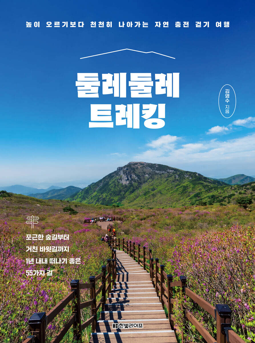
A trekking YouTuber with 220,000 subscribers, Kim Young-soo introduces great routes to take all year round. Into our country's pristine nature, filled with the joy of walking and seeing! Sometimes we are captivated by a beautiful landscape photo and travel there. When I go into nature to find that scenery and see it with my own eyes, I am overwhelmed with emotion. Why does nature, when it's just nature, touch us with such profound emotion? Perhaps it's the mystery of nature itself, but perhaps it's the act of actively moving your body and walking to see the scenery, which allows you to let go of the worries of everyday life and fully experience nature. The sound of leaves swaying in the wind, the chirping of birds, the fresh scent of grass, the soft dirt road, and even the magnificent scenery that can only be seen by walking. As you walk, focusing on all these sensations, you will be deeply moved by nature, and peace of mind and physical health will follow. Trekking is the trip that allows you to properly experience this series of processes. 《Trekking Around》 is a trekking YouTuber selected by over 220,000 subscribers. The author personally walks all over the mountains and rivers of Korea and selects and introduces the most beautiful and walking trails in all seasons. I traveled all over the country from Seoul to Jeju, visiting the same places multiple times to select the best walking course and time. If you prefer walking rather than hiking, these are courses of a difficulty level that are worth challenging. Each course includes a map that allows you to see the route at a glance. This map, unlike any other, contains key information about the course, including the starting point, transportation, and attractions, and even shows the slope of each section. In addition, it includes information on not only trekking courses but also nearby tourist attractions and restaurants, helping you complete your trip beyond just trekking. Let's embark on a walking tour of our country, following mountains and rivers, in search of landscapes that will deeply move our hearts, with this book. |
- You can preview some of the book's contents.
Preview
index
Author's Note
Structure of this book
PART 1: Trekking Basics for Beginners
Basic trekking preparation
12 Best Trekking Courses
Recommended trekking courses by theme
Basic trekking equipment
Trekking Precautions and Tips
Useful sites and apps
PART 2 Trekking in Seoul, Incheon, and Gyeonggi-do
Seoul Trail Course 2
Bukaksan Mountain in Seoul
Seoul Gwanaksan Yeonjudae-Sadang Ridge
Incheon Muuido-Somuido
Ansan Gubongdo
Suwon Hwaseong Fortress
Namhansanseong Fortress in Gwangju
Yeoju Yeogang-gil Course 8 (Pasaseong-gil)
Pocheon Byeoreutgil-Busocheon Circular Trail
Yeoncheon Yeongang Ferry Road Course A
PART 3 Trekking in Gangwon-do
Cheorwon Hantangang Columnar Joint Road
Cheorwon Hantangang River Waterway
Chuncheon Samaksan Mountain
Inje Seoraksan Bongjeongam
Yangyang Heullimgol-Jujeongol
Pyeongchang Seonjaryeong
Jeongseon Mindungsan Mountain
Donghae Dutasan Battle Rock-Skyscraper
Samcheok Isabu-gil - Chuwam Candlestick Rock
Taebaek Taebaeksan Yuilsa Temple-Cheonjedan
PART 4 Trekking in Chungcheong Province
Daejeon Jangtaesan Natural Recreation Forest
Danyang Slow River Reinforcement Trail Course 5-4
Jecheon Gudambong-Oksunbong
Goesan Sanmaki Old Road - The Road of the Bride and Groom
Boeun Songnisan Sejo-gil-Gyeongeopdae
Yeongdong Woryu Peak Trail
Hongseong Yongbongsan Mountain
Seosan Gangdaengi Maitreya Buddha - Gaesimsa Temple
Taean Beach Road Course 1 (Baragil)
Taean Solhyanggi Trail Course 1
PART 5 Trekking in Jeolla-do
Gunsan Seonyudo-Daejangdo
Gochang Seonunsan Sunset Deck
Sunchang Yonggwolsan Mountain
Namwon Baraebong
Jinan Maisan
Damyang Geumseongsanseong Fortress
Yeosu Yeongchwisan Mountain
Gangjin Dasan Chodang-Baekryeonsa-Gitdaebong
Haenam Mihwangsa Temple-Dosol Am-Dalmagodo
Shinan Bigeumdo Island
PART 6 Gyeongsang-do Trekking
Daegu Bisulsan Mountain
Bonghwa Nakdonggang Sepyeong Sky Road Yangwon Station-Seungbu Station
Bonghwa Cheongnyangsan Mountain
Andong Scholar Pilgrimage Route 5 (Wangmosan Fortress Trail)
Juwangam, Juwangsan Mountain, Cheongsong
Pohang Naeyeonsan 12 Waterfalls
Yaksaam Hermitage, Geumosan Mountain, Gumi
Hamyang Scholar Culture Trail Section 1
Hapcheon Hwangmaesan Rhododendron Grove - Sunkyulbawi Ridge
Hadong Sinsendae-Gososeong
PART 7 Jeju Island Trekking
Jeju Hallasan Mountain Trail Sections 9-8
Jeju Hallasan Eorimok Trail-Yeongsil Trail
Jeju Darangshi Oreum - Akkeundarangshi Oreum
Seogwipo Jeju Olle Course 7 Oedolgae-Akgeuncheon
Seogwipo Songaksan Mountain
Detailed image

Publisher's Review
If you want to walk more than just hiking, but more than just taking a stroll!
A trekking course that everyone can enjoy
Trekking is completely different from mountaineering, which aims to conquer a peak.
I walk with the desire to take each step at my own pace, feel the change of seasons and the passage of time, and fully enjoy the beauty of nature up close.
So, this book contains courses of various difficulty levels, from places that can be easily attempted by beginners who are not familiar with trekking or people with bad joints who find ups and downs difficult, to places that can be attempted after getting used to trekking.
Additionally, because the course difficulty is categorized by precise criteria, you can easily choose a course that suits your physical strength.
All trekking courses are carefully selected by the author through numerous visits to various parts of the country.
It is full of colorful charms that show new scenery depending on the season, so it is good to visit just once, but it is even better to visit multiple times.
All paths are beautiful, from easy valley paths with little elevation change for those who simply want to get deep into nature and enjoy the scenery, to challenging mountain paths with beautiful scenery that will wash away your fatigue.
Find out the course with a unique map you've never seen before
Scan the QR code to preview the course with a video link.
When trekking, one thing that people consider important is a map.
Because there are multiple courses to the same place, it is easy to figure out which way to go and how far to walk, and which direction to go to get to that place.
However, when you look at a general map that only allows for flat representation, you may expect a short distance, but when you actually go there, there are countless cases where it takes twice as long or is not suitable for your physical strength due to the steep uphill slope.
So, we have included a map that expresses even the slope of the road in such detail that it has never been seen before.
Even before reading the text, just by looking at the map, you can see the distance of each section, the slope of the path, the junctions, and the main points with things to see, so you can get a quick idea of the difficulty level and how to get there before setting off on the trek.
Also, because understanding it in your head is different from actually experiencing it, QR codes have been included in every course so that you can preview the course through videos shot by the author himself.
Maps, videos, the author's writing, and beautifully captured photos come together to create a clear and vivid understanding of the course.
Useful for both beginners and veterans!
A guide packed with everything from theme-based recommendations to information on trekking.
The trekking courses are diverse, including recently opened routes and routes newly created by the author, making them useful even for veterans.
We also did not leave out basic information for beginners.
We will guide you step by step through the basic preparations, precautions, supplies, and even useful websites and apps that are easy to overlook.
In particular, the author recommends the best trekking courses that you must visit, as well as courses with spectacular views according to the season, so you can enjoy trekking all year round.
Transportation information provides parking information, which is crucial for those who drive, and detailed information on public transportation for those who are on the go.
Depending on the course, if the starting point and the ending point are different rather than returning to the origin, you don't have to worry about getting lost as it even tells you how to return to the starting point.
It also helps you complete your trekking journey by providing recommendations for delicious restaurants that will increase your satisfaction with your trip and nearby tourist attractions that are great for a quick stop after trekking.
Check the places you want to go one by one while looking at the evangelism
Record your own completion with a trekking tracker.
There is a special appendix that can only be found in 『Durumulure Trekking』.
This is a poster showing the locations of the 55 trekking courses in Korea included in the book.
The trekking courses are marked in the order in which they appear in the text, with numbers.
Just as each course in the book is divided into regions, each city and province is divided into districts, and the locations of the major mountain ranges in our country are expressed so that they can be seen.
It's not just about preaching.
We've put together a trekking tracker so you can record your completion of each of the 55 courses.
The trekking tracker has the trekking course numbers and course names symmetrically displayed on the trail.
You can write the date you completed the race in the blank space, and decorate the 55 numbers in your own way, such as by coloring or attaching stickers to the course numbers.
This is a special supplement that doubles the fun of trekking as you gain a sense of accomplishment and satisfaction each time you fill it out.
GOODS SPECIFICS
- Date of issue: June 15, 2023
- Page count, weight, size: 376 pages | 842g | 175*235*20mm
- ISBN13: 9791193080047
- ISBN10: 1193080045
You may also like
카테고리
korean


korean

![ELLE 엘르 스페셜 에디션 A형 : 12월 [2025]](http://librairie.coreenne.fr/cdn/shop/files/b8e27a3de6c9538896439686c6b0e8fb.jpg?v=1766436872&width=3840)


