

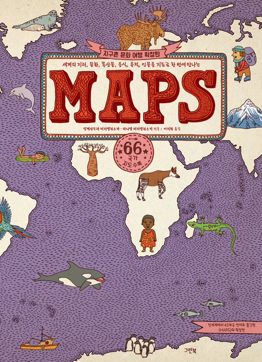
MAPS (Expanded Edition)
 |
Description
Book Introduction
- A word from MD
-
The first step into a wider worldAn exciting world tour of 66 countries across 6 continents with a large map that encompasses the entire world.
From geography and culture to local specialties, historical sites, and people, the book stands out for its meticulous attention to detail that doesn't miss a single aspect of our neighbors living around the globe.
The detailed illustrations and text filled with sincerity are also something you can't miss.
December 15, 2023. Children's PD Park Eun-young
The world is getting closer and closer!
A fun world tour driven by your interests and curiosity!
An expanded edition of "Global Cultural Journey," which has sold over 3 million copies worldwide and been published in 43 languages, has been released.
This 『MAPS (Expanded Edition)』 has arrived with content that will allow children living in an increasingly global village to explore a wider world and more countries.
The list of travel destinations available to children has expanded, with eight new countries added to the list, not just those we know well, but also across Eastern Europe, the Middle East, Southeast Asia, Africa, and Central and South America.
In this book, painstakingly written and illustrated by a world-renowned Polish author couple, readers will encounter geography, culture, specialties, food, historical sites, and people from around the world, along with fun and friendly illustrations.
More accurate information has been added, and authors are guiding the world with a more reliable perspective.
Shall we begin another wonderful world tour?
- You can preview some of the book's contents.
Preview
index
6 Europe
8 Iceland
10 Norway
12 Denmark
14 Sweden
16 Finland
18 Estonia
20 Latvia
22 Lithuania
24 Ireland
26 UK
28 Netherlands
30 Belgium
32 Germany
34 Switzerland
36 Austria
38 Poland
40 Czech Republic
42 Slovakia
44 Hungary
46 Ukraine
48 France
50 Portugal
52 Spain
54 Italy
56 Slovenia
58 Croatia
60 Romania
62 Greece
64 Asia
66 Russia
68 Georgia
70 Turkiye
72 Iran
74 Jordan
76 Mongolia
78 China
80 Taiwan
82 Republic of Korea
84 Japan
86 India
88 Nepal
90 Thai
92 Vietnam
94 Indonesia
96 Africa
98 Morocco
100 Egypt
102 Ghana
104 Nigeria
106 Ethiopia
108 Democratic Republic of the Congo
110 Tanzania
112 Namibia
114 South Africa
116 Madagascar
118 North America
120 Canada
122 United States
124 Mexico
126 Cuba
128 South America
130 Venezuela
132 Ecuador
134 Peru
136 Brazil
138 Chile
140 Argentina
142 Oceania
144 Australia'
146 New Zealand
148 Fiji
150 Arctic
152 Antarctica
154 Flags of various countries around the world
Detailed image
.jpg)
Publisher's Review
75 large maps
We'll take you to 66 countries across 6 continents!
66 countries from six continents – Europe, Asia, Africa, the Americas, Oceania, and Antarctica – are depicted on 75 large maps.
Starting with a map that encompasses the entire world, 《MAPS》(Expanded Edition) allows readers to first find and explore the countries that interest them according to their own interests and curiosity.
Continental maps show the boundaries of continents, the countries that make up a continent, and the surrounding oceans and the creatures that live there.
On the maps of individual countries, readers can freely explore the nature, culture, people, and customs of each country.
This expansion adds 8 more countries to the 58 introduced in the previous 《MAPS》.
Newly introduced are Slovenia in Europe, Iran and Indonesia in Asia, Nigeria, Ethiopia and the Democratic Republic of the Congo in Africa, Cuba in North America, and finally Venezuela in South America.
We can meet not only countries that are well known to us, but also countries that have received relatively less attention.
Why not take this opportunity to explore the world, including countries that have become important to us in this changing social environment?
Obtained through the authors' meticulous research and revision
More accurate information is back in text and pictures!
Even after the publication of 《Global Cultural Journey》 and 《MAPS》, the authors continued to diligently research the countries featured in their previous books and those they would include in new ones.
This was to check for any facts that may have been incorrect and to reflect in the book any changes in the international situation.
As a result, the artists had to revise over 200 drawings.
It is changed or added to a more accurate location, appearance, description, etc.
It's not easy to change the content of an existing book, but the authors didn't give up and added new and more accurate information to the book.
We also persuaded overseas publishers to help us produce better books.
The Korean version of 《MAPS》(Expanded Edition) shows the exact location of Incheon Bridge in Korea and also adds a description of Queen Elizabeth II of England.
Many other things have been changed or added as well.
With a reliable, balanced perspective
Look at the world!
The authors of 《MAPS》(Expanded Edition) love to travel and loved the illustrated monthly encyclopedias they read as children.
These memories and tendencies of theirs were carried over into the carefully written and illustrated series “Global Cultural Travel” and “MAPS.”
But the book was not only filled with their passion, but also with the enthusiastic support of many readers.
And after listening to readers' stories, the writers, after much deliberation, came to see and present the world from a more trustworthy and balanced perspective.
Beyond simply introducing the world's most influential figures, the expanded edition also features writers, politicians, and human rights activists who are still making a significant impact today.
By highlighting respected figures instead of historically problematic ones, and by not leaving out small and marginalized peoples and groups, we are portraying a global village where we all live together regardless of size.
Let's take a look at some of our neighbors living on our planet.
The writers' sincerity, the writers' spirit alive and breathing
Enjoy the best-selling map book filled with illustrations and text!
From the time of creating 《Global Cultural Journey》, the authors drew vivid pictures one by one, created fonts exclusively for this book, and hand-wrote the names of countries in every language.
The Korean version of 《MAPS》(Expanded Edition) also contains the same dedication of the authors.
The authors say they hope this book will be a beginning, not an end.
I hope that children and adults alike will enjoy this book as they travel the world, following their own interests and curiosity.
He hopes that this book will serve as a starting point for people to learn more about countries they are interested in, and eventually travel to those countries themselves.
Shall we all go on a free and fun world tour together?
Curriculum linkage
1st Grade Integrated (Winter) 1.
This is our country | 2nd grade integrated (winter) 1.
Heart-pounding world tour
3-2 Social 3.
Various aspects of life | 4th grade ethics 6.
A rainbow world we dream of together
5th grade home economics 3.
Flora and Fauna in Everyday Life | 6-2 Social Studies 3.
Nature and culture from various regions around the world
GOODS SPECIFICS
- Publication date: November 28, 2023
- Format: Hardcover book binding method guide
- Page count, weight, size: 160 pages | 1,354g | 277*379*17mm
- ISBN13: 9788955884487
- ISBN10: 8955884486
You may also like
카테고리
korean


korean

![ELLE 엘르 스페셜 에디션 A형 : 12월 [2025]](http://librairie.coreenne.fr/cdn/shop/files/b8e27a3de6c9538896439686c6b0e8fb.jpg?v=1766436872&width=3840)


