

A picture book that shows the map of our country at a glance
 |
Description
Book Introduction
An exciting national tour with a picture map
Our country's nature, history, and culture at a glance!
The 2025 revised edition of “Our Country’s Map Picture Book at a Glance” has been published.
From basic information such as each region's area and population to cultural heritage sites, scenic spots, and local festivals, we've updated our country's natural and cultural information with the latest data and reflected it on the map.
"Our Country at a Glance Picture Book" presents the characteristics of various regions of our country with detailed maps and interesting illustrations, allowing children to become closer to maps and learn about our country's geography with greater interest.
It contains easy-to-understand information on one special city, nine provinces, six metropolitan cities, one special autonomous city, and important geographic information of North Korea.
You can also explore cultural heritage sites, local festivals, and local specialties worth visiting throughout the country, which helps with experiential learning.
- You can preview some of the book's contents.
Preview
index
Our country - Our country boasts a long history of 5,000 years.
Seoul - the proud capital of the Republic of Korea
Gyeonggi-do - the center of the Korean Peninsula connecting Seoul and the provinces
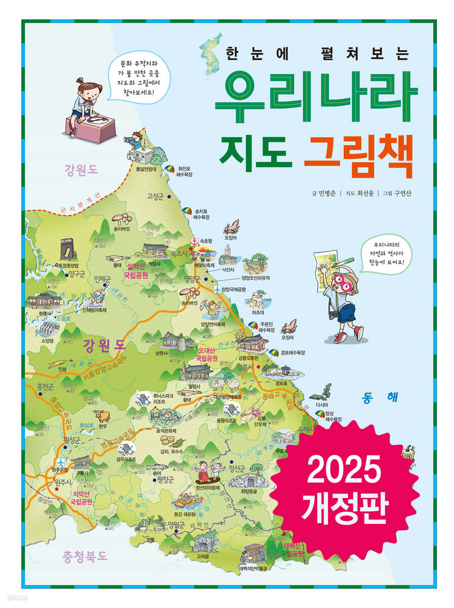
Gangwon Special Self-Governing Province - Gwandong region with many high mountains
Chungcheongbuk-do - the only inland region without access to the sea
Chungcheongnam-do - a region that preserves the gentle and elegant Baekje culture
Jeonbuk Special Self-Governing Province - A region of traditional culture encompassing the Honam Plain
Jeollanam-do - A land of history with a thousand years of flavor and style
Gyeongsangbuk-do - a region preserving the history and culture of Silla
Gyeongsangnam-do - the ancient land of Gaya, where iron culture flourished
Jeju Special Self-Governing Province - the largest island designated as a World Natural Heritage Site
Busan Metropolitan City - South Korea's largest maritime city in the Pacific Rim era
Incheon Metropolitan City - A towering international city at the center of Northeast Asia
Daegu Metropolitan City - The central region of Yeongnam that led the modernization of South Korea
Gwangju Metropolitan City - the center of the Jeolla region and a center of culture and arts
Daejeon Metropolitan City - A transportation and logistics hub, formerly known as Hanbat
Ulsan Metropolitan City - Korea's leading industrial city
North Korea - The Half of the Korean Peninsula That Should Be Unified Through Peaceful Reunification
Korea at a glance - Northern region, Seoul metropolitan area, Gangwon-do, Chungcheong-do, Jeolla-do, Gyeongsang-do, and Jeju-do
Search
Seoul - the proud capital of the Republic of Korea
Gyeonggi-do - the center of the Korean Peninsula connecting Seoul and the provinces
Gangwon Special Self-Governing Province - Gwandong region with many high mountains
Chungcheongbuk-do - the only inland region without access to the sea
Chungcheongnam-do - a region that preserves the gentle and elegant Baekje culture
Jeonbuk Special Self-Governing Province - A region of traditional culture encompassing the Honam Plain
Jeollanam-do - A land of history with a thousand years of flavor and style
Gyeongsangbuk-do - a region preserving the history and culture of Silla
Gyeongsangnam-do - the ancient land of Gaya, where iron culture flourished
Jeju Special Self-Governing Province - the largest island designated as a World Natural Heritage Site
Busan Metropolitan City - South Korea's largest maritime city in the Pacific Rim era
Incheon Metropolitan City - A towering international city at the center of Northeast Asia
Daegu Metropolitan City - The central region of Yeongnam that led the modernization of South Korea
Gwangju Metropolitan City - the center of the Jeolla region and a center of culture and arts
Daejeon Metropolitan City - A transportation and logistics hub, formerly known as Hanbat
Ulsan Metropolitan City - Korea's leading industrial city
North Korea - The Half of the Korean Peninsula That Should Be Unified Through Peaceful Reunification
Korea at a glance - Northern region, Seoul metropolitan area, Gangwon-do, Chungcheong-do, Jeolla-do, Gyeongsang-do, and Jeju-do
Search
Detailed image
.jpg)
Publisher's Review
『A Map of Korea at a Glance Picture Book』 Revised Edition to be published in 2025!
The revised edition of “Our Country’s Map Picture Book at a Glance” has been published.
From basic information such as each region's area and population to cultural heritage sites, scenic spots, and local festivals, we've updated our country's natural and cultural information with the latest data and reflected it on the map.
Traveling Korea with detailed maps and illustrations
What does our country look like? Where do the rivers flow? How far do the roads and railways extend? What attractions are there to see in a new place? Maps depict the land from above, and are the most useful way to get a bird's-eye view of where we live.
Knowing the map will help you understand your hometown and, by extension, our entire country.
"Our Country at a Glance Picture Book" presents the characteristics of various regions of our country with detailed maps and interesting illustrations, allowing children to become closer to maps and learn about our country's geography with greater interest.
Cultural heritage, local festivals, specialties, and other regional characteristics at a glance!
Each region of our country has its own unique characteristics that have evolved over time according to its environment.
Each region has its own unique natural beauty, including mountains and lakes, industries that reveal the lives of its people, cultural assets left behind by our ancestors, and representative festivals and famous local specialties.
This book contains easy-to-understand information on the one special city, nine provinces, six metropolitan cities, and one special autonomous city that make up our country, as well as important geographical information on North Korea.
The map is decorated with detailed pictures containing various information and added with fun speech bubbles, so that the characteristics of each region can be seen at a glance just by looking at the map.
We've also included interesting geography quizzes for each region to help you review important information.
Packed with helpful information for your experiential learning trip!
When traveling with family, the more you know about other places, the richer your trip will be.
If you know in advance whether your destination is a mountain or a beach, a cold or hot place, and the cultural heritage of the area, you can have a more fulfilling and enjoyable experience.
This special map picture book introduces our country's nature, history, and culture at a level suitable for children, and is useful to keep close at hand and refer to often.
How about looking up places you've traveled with your child in a book, talking about places you'd like to visit, and dreaming of traveling around the country?
● Features of the revised edition of 『Our Country's Map Picture Book at a Glance』
1.
Detailed maps created by experts
If you simplify the map just because it's a children's book, it can easily become distorted.
The most important maps in geography are carefully crafted by experts and contain up-to-date information.
2.
Easy to learn map reading
Cultural heritage, local festivals, and specialties are displayed as pictures on the map to help children easily understand the map.
If you familiarize yourself with the map legends included at the front of the book, you will be able to read the maps more easily and become familiar with them naturally.
3.
Consists of concise explanations and fun illustrations
We've compiled some important information to help you understand each region of our country.
We have tried to make it as concise as possible to suit children's reading ability and have included fun illustrations to increase understanding.
4.
Contains geographic information for the entire Korean Peninsula
It includes comprehensive information on one special city, nine provinces, six metropolitan cities, one special autonomous city, and even geographic information on North Korea.
Just by looking at the map, you can easily organize various information and see the characteristics of our country at a glance.
5.
Korean geography quiz that will make you smarter!
We've repackaged the information we've covered for each region into engaging quizzes to help you remember it more easily.
At the same time, you can enjoy fun quizzes during your exciting trip.
GOODS SPECIFICS
- Date of issue: June 10, 2025
- Page count, weight, size: 40 pages | 680g | 262*350*10mm
- ISBN13: 9791193003756
- ISBN10: 119300375X
- KC Certification: Certification Type: Conformity Confirmation
You may also like
카테고리
korean


korean

![ELLE 엘르 스페셜 에디션 A형 : 12월 [2025]](http://librairie.coreenne.fr/cdn/shop/files/b8e27a3de6c9538896439686c6b0e8fb.jpg?v=1766436872&width=3840)


