

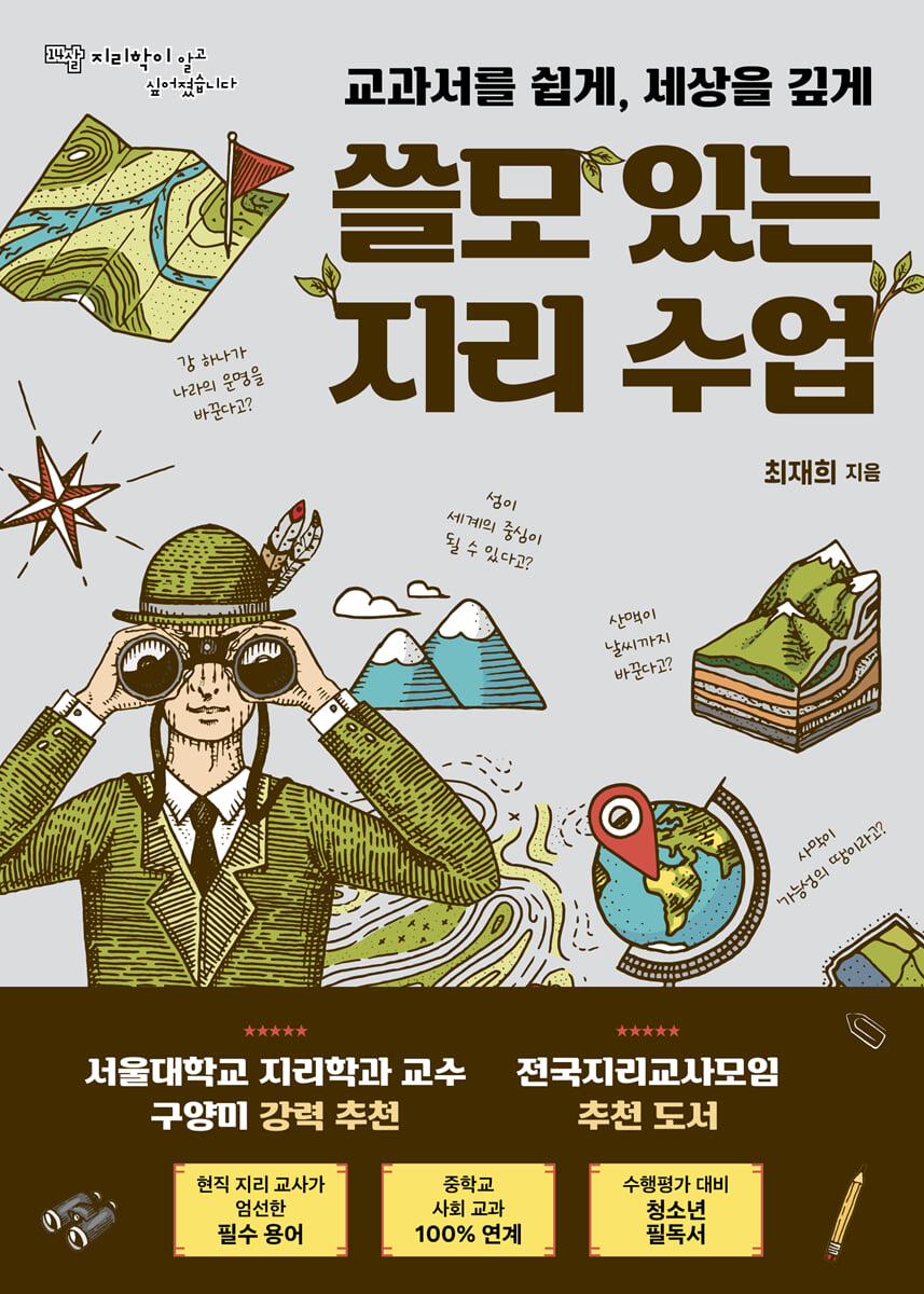
Useful geography lessons
 |
Description
Book Introduction
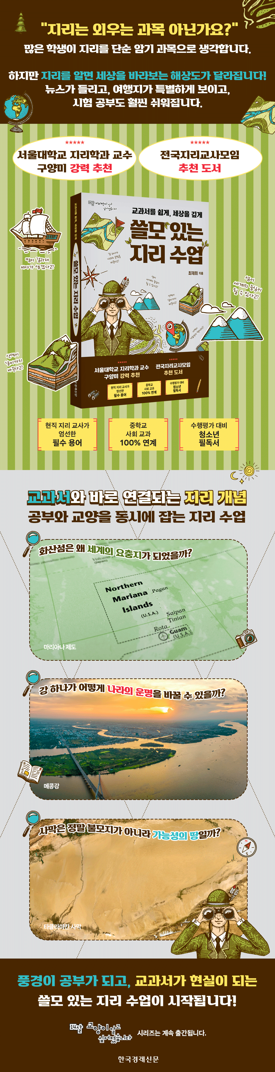
The scenery looks different, and the world becomes more curious.
Useful geography lessons begin!
Highly recommended by Professor Guyangmi of Seoul National University's Department of Geography | Recommended by the National Association of Geography Teachers
★ Includes essential terms carefully selected by current geography teachers ★
★ 100% linked to middle school social studies ★
★ Must-read for Teenagers to Prepare for Performance Assessments ★
《Useful Geography Lessons》 is a youth education book that helps students view geography not as a simple object of memorization, but as a tool for understanding the world.
Geography emphasizes that it is not a mere listing of information in textbooks, but rather a study of the dynamic narrative created by the interplay between the natural environment and human life.
The author, feeling the need for 'useful geography studies' with students in the classroom, wrote this book to foster the ability to view the world through geography.
The book is divided into three parts: Asia, Europe/Africa, and America/Oceania, and focuses on the continents' major natural environmental elements (volcanic islands, rivers, deserts, coasts, faults, mountain ranges, basins, deltas, etc.) to unravel their human history, culture, and geopolitical significance.
For example, we will examine why the Mariana Islands are not simply volcanic islands but rather a strategic point of intersection of maritime powers; what is the geopolitical significance of the Red Sea, which was created when a huge landmass split apart; and how the Amazon Basin, the Great Lakes, and the Paraná Delta are closely linked to real-world issues such as environmental crises, trade, tourism, and war today.
The author says that people who study geography have a different perspective on travel, daily life, and social issues.
Even if you travel to the same city of Busan, if you can read the context of urbanization contained in the mountain roads and elevated roads, the fun of the trip will naturally change.
If you truly understand the geography of Busan, you can begin to imagine how the apartment complexes that rise up to the hillsides, the mountainside roads that occupy the steep slopes, and the elevated highways that connect various parts of the city have become Busan's representative landscapes.
This is because it is the result of the urbanization process that caused a large population to gather in a narrow coastal area in a short period of time due to the high proportion of mountainous areas.
In this way, this book helps students understand textbook concepts in context and conveys the joy of reading the world in a new way.
In addition, at the end of each chapter, there are 'Two-Line Summary of the Story', 'Summary of Textbook Terms', 'Read More', and 'Think More' to help with learning effectiveness and expanding thinking.
This book, which serves as a guide that adds depth to textbook learning and a new window for understanding the world, clearly demonstrates that studying geography is a 'useful study.'
- You can preview some of the book's contents.
Preview
index
Prologue: Enter the world of useful geography studies!
Part 1.
Asia - The moment when the power of the land changes people's lives
Chapter 1 Volcanic Island (Mariana Islands) - Can a small island become the center of the world?
Chapter 2 Rivers (Mekong River) - Can one river change the fate of a country?
Chapter 3 Karst (Guilin) - How did limestone create such a mysterious landscape?
Chapter 4: The Desert (Taklamakan) - Why is the desert called the 'land of possibility'?
Part 2.
Europe and Africa - A History of Humanity Shaped by Seas and Coastlines
Chapter 5 Coast (Pulse Bay) - Can the shape of capes, bays, and coasts change history?
Chapter 6: Tidal Flats (Wadden Sea) - Treasures found in the drained sea?
Chapter 7 Coastline (Norwegian Coast) - Why does a complex coastline become a tourist destination and trading port?
Chapter 8 Fault (Red Sea) - A huge land split created the sea?
Part 3.
America and Oceania - Geographic Secrets on Land
Chapter 9 Lakes (Great Lakes) - Where is this vast water kingdom formed by melting ice?
Chapter 10: Basin (Amazon Basin) - Is the Amazon Rainforest the Lungs of the Earth?
Chapter 11 Folded Mountains (Great Dividing Range, Southern Alps) - Do rising mountain ranges change the climate?
Chapter 12 Delta (Parana Delta) - Is it true that the land created by the river is this vast?
Epilogue: The Power of Geography to See the World in a Broader and Richer Way
Detailed image
Into the book
Interestingly, the theme that resonated with everyone on this journey to discover the special utility of geography was the understanding of large geographical spaces such as mountain ranges, rivers, and plains that humans have long chosen as living spaces.
As a consensus was formed that “the mountains, fields, and rivers that we usually pass by without a second thought are closely related to our lives,” we began to seriously connect the natural environment with human life.
This book began with the intention of looking into the colorful human lives that are added to the outline of a space familiar to young people.
--- p.6, from the main text, “Prologue”
Have you ever seen the animated film "Kung Fu Panda"? The main character is a giant panda named Po.
Po, who lives in the Valley of Peace, works in his father's noodle shop, but contrary to his father's wishes for him to become a noodle master, he only dreams of becoming a kung fu master.
One day, Po goes to the arena to watch the "Invincible Five" competition to determine the successor to the Dragon Scroll, which contains the secrets of kung fu. There, the Grand Master nominates Fu as the successor to the Dragon Scroll.
From then on, Po's master Shifu began teaching Po kung fu.
Why am I suddenly talking about Kung Fu Panda? It's to talk about the space where Po learns martial arts and is given the title of Dragon Warrior.
--- p.56, from the text, “Chapter 3: How did limestone create such a mysterious landscape?”
The next most striking coastline after Perth is Hout Bay.
Hout Bay is a suburban area west of Pearls Bay.
It is famous for its dangerous and powerful waves, which any surfing enthusiast would have heard of at least once.
Dungeons Spot, where waves reach up to 15 meters, is so notorious that many surfers have lost their lives competing in surfing competitions.
The high and dangerous waves that form around Hout Bay are also due to geographical conditions.
It is the condition of the sea floor that increases the waves that wash up on the beach.
When solid rock or coral reefs block the incoming waves, the kinetic energy of the water is converted into potential energy, creating higher waves.
--- p.105, from Chapter 5, “Can the shape of capes, bays, and coasts change history?”
The geopolitical significance of the Port of Saint-Nazaire was demonstrated during the two world wars of the 20th century.
The geopolitical significance of the port of Saint-Nazaire, which can control Europe, America, and the Mediterranean, is so significant that the shipyards of Saint-Nazaire originally focused on building warships rather than cruise ships.
The fact that Nazi Germany occupied the port of Saint-Nazaire during World War II and used it to build a powerful submarine bunker also testifies to its geopolitical importance.
--- p.133, from the text, “Chapter 6: Treasures Found in the Drained Sea?”
If you've seen the movie "Roaring Currents," which attracted 10 million viewers, think about it.
The enemy commander Yasuharu Wakizaka is afraid of Admiral Yi Sun-sin.
That is understandable, as he had barely escaped with his life in the Battle of Hansando.
On the other hand, Kurushima Michifusa, who was portrayed as the enemy general in the Battle of Myeongnyang, appears in the film in a scene where he boasts that he knows more about the Rias Coast than Admiral Yi Sun-sin.
Kurushima was active in the waters off Kyushu, Japan, and since the waters off Kyushu were also a rias coast, they thought they had a good chance of winning.
However, Kurushima, who faced off against Yi Sun-sin's fleet of about 10 ships at Myeongnyang, was defeated despite leading an overwhelming fleet of over 300 ships, and eventually lost his life.
Myeongnyang (Uldolmok) is a battlefield that provides a glimpse into Admiral Yi Sun-sin's outstanding understanding of the Rias Coast.
--- p.148, from Chapter 7, “Why do complex coastlines become tourist destinations and trading ports?”
The Amazon Basin is a vast basin that holds the large and small streams of the Amazon River.
The overwhelmingly large tropical forest created in this giant bowl is called Selvas.
Selva comes from the Latin word silva, meaning forest, so Selvas literally means 'forest feast'.
Selvas, filled with tropical forests, is nicknamed the 'treasure trove of biodiversity'.
It's truly amazing that in Selvas, dozens to hundreds of new species can be discovered every year, right?
--- p.210, from the text, “Chapter 10: Is the Amazon Rainforest the Lungs of the Earth?”
The natural water tower effect of the Singi Fold Mountains is even more powerful in dry areas with little rainfall.
Most people living on the arid Tibetan Plateau and in the deserts of the American West depend on the natural water towers of the Singi Fold Mountains.
In arid regions where natural water towers are unavailable, obtaining water can be extremely expensive.
That's Dubai in the United Arab Emirates.
Dubai does not have any natural water towers like the Sinai Fold Mountains around it.
So we're building massive plants to turn seawater into freshwater to make drinking water.
So a city like Dubai cannot be sustainable.
It means that the natural geographical conditions have a value that cannot be bought with money.
--- p.231, from the text, “Chapter 11: Is the climate changing because of the rising mountain range?”
Any place where human activities exceed the geographical conditions provided by nature is always in danger of environmental crisis.
This is evidenced by the rapid environmental changes occurring on Easter Island long ago and on the Galapagos Islands and Madagascar today.
Nowadays, we can no longer see the world properly through a list of fragmentary facts.
To see the world from a rich and comprehensive perspective, geographical thinking is not an option but a necessity.
--- p.263, from the main text, “Epilogue”
Publisher's Review
When the contents of the textbook are connected to real events, news, and travel destinations,
Geography is no longer a subject to be memorized!
Beginning with questions like “Why did a volcanic island become a strategic point?”, “How can a single river change the fate of a nation?”, and “Is the desert really a land of possibility rather than a wasteland?”, this book, which fosters the ability to see and understand the world, travels across Asia, Europe, Africa, the Americas, and Oceania, and fascinatingly unravels the surprising connections between the natural environment and human life.
Each chapter connects textbook concepts with real-world examples, providing an engaging account of how natural landforms have shaped human life, world history, and civilization.
Part 1, Asia, explores how the power of the earth transforms people's lives through volcanic islands, rivers, karst, and deserts.
The reason why the Mariana Islands reveal their significance as volcanic islands and a geopolitical hub, and why the Mekong River is both a lifeline shared by six countries and a source of conflict, is explained through the topography of rivers.
The karst landscape of Guilin, China, showcases the wonders of nature while also serving as a tourist attraction, offering a glimpse into how the lives of the people who live there have changed.
Furthermore, the Taklamakan Desert demonstrates that even in a harsh natural environment, the desert can become a "land of possibility" where trade and civilization flourish.
Part 2: Europe and Africa explore diverse coastlines and fault lines to learn about how human history and civilization unfolded.
The shape of the coast can change history, and through the topography of the capes and bays of Pulse Bay, we learn about the development of a port city, and we realize that the terrain of the tidal flats can become a treasure trove for humanity through the difference between high and low tides.
Norway's rias and fjord coasts are examples of how complex coastlines foster tourism and trade, while the fault lines of the Red Sea illustrate how land splits to create new seas, marking the shifting boundaries of continents and countries.
Part 3, America and Oceania, illuminates the secrets of geography encountered on land through the landforms of lakes, basins, mountain ranges, and deltas.
The Great Lakes are a vast freshwater resource formed by melting glaciers, and the Amazon Basin is the 'lungs of the Earth', explaining why they are directly linked to the future of humanity.
The Great Dividing Range and the Southern Alps are introduced as folded mountain ranges that rose up due to plate collisions, changing the climate and even human lifestyles, and the Paraná Delta is introduced as an example of how a river created a sedimentary landform as large as the sea, supporting human life.
A Journey of Civilization with Geography
Discover true liberal arts that go beyond studying and connect to your life!
The greatest benefit of this book is that it helps us realize that geography is not simply knowledge found in textbooks.
The book does not simply present diverse natural environments such as volcanic islands, rivers, deserts, mountain ranges, tidal flats, and deltas as concepts to be memorized.
Instead, it vividly shows how it influenced real history, events, and today's social issues.
For example, the Mariana Islands, a volcanic island chain in the Pacific Ocean, are not simply a geographical example; they explain why they have become a geopolitically central location for the world.
The Wadden Sea tidal flats are not simply a beach, but a vast treasure trove of humankind created by the tidal differences, introducing the geographic role of tidal flats.
It explains that the Amazon Basin is not just a simple rainforest, but an environmental space directly linked to the future of the entire planet, providing young readers with a clear answer to the question, "Why should we study this geography?" and increasing their motivation to learn.
Additionally, this book has excellent curriculum connectivity.
The terrain covered in each chapter aligns with key learning elements found in middle school social studies and geography textbooks and is expanded upon with real-world examples.
Therefore, readers can understand the textbook content more easily and gain ideas that can be immediately applied to performance assessments, discussions, and research reports.
Rather than treating geography as a subject to be memorized for exams, it is about transforming what you learn into a thought process that connects it to your own life and the world.
Above all, this book develops the ability to think and the sense of being a global citizen.
When students learn that issues they see in the news—such as climate change, international conflicts, and resource issues—are not abstract narratives but are connected to geographic concepts in textbooks, they gain the power to understand the world.
The book's message, "The scenery becomes a study, and the textbook becomes reality," clearly demonstrates this educational value.
So, “Useful Geography Lessons” has two meanings.
For young people, this book is a practical aid to academic achievement and exploration, while also providing the pleasure of learning new things about the world through geography.
As you follow each page, you will naturally realize that geography is not simply a subject to memorize for exams, but a useful study that helps you understand the world and enrich your life.
GOODS SPECIFICS
- Date of issue: October 20, 2025
- Page count, weight, size: 268 pages | 458g | 150*210*15mm
- ISBN13: 9788947502016
- ISBN10: 8947502014
You may also like
카테고리
korean


korean

![GQ KOREA Mark (Monthly): December [2025]](http://librairie.coreenne.fr/cdn/shop/files/8ef265dbbfbf186523ed75ba7319009d.jpg?v=1765340328&width=3840)


