

You might fall in love with it if you get to know it
 |
Description
Book Introduction
Our old map, if you get to know it, you might fall in love with it?
From [Cheonhado] to [Sujin Il Yong Bang],
A Humanities Journey Through Old Maps with Colorful Stories
- All the old maps are drawn in strange shapes. How should we interpret them?
- What were the ‘thoughts’ of the ancient people when they drew such a map?
- What kind of ‘people’s’ stories and what kind of historical ‘stories’ are contained in old maps?
Maps are a scientific product that provides convenience in life as they contain accurate geographical information.
However, maps, expressed with brilliant colors and elaborate descriptions, provide an aesthetic sensation no less than that of a masterpiece painting, and in showing the world we live in like a story, they stimulate the imagination no less than any other literary work.
In particular, old maps were not created scientifically.
The maps created by ancient people, crossing the boundaries of reality and imagination, were imbued with fervent hopes and longings, regrets and sorrows, light humor and profound emotions. This is why simply looking at a map makes our hearts race and arouses yearning and curiosity.
In this way, old maps possess the dual charm of ‘scientific’ and ‘artistic’, and are also comprehensive works of art that combine points, lines, planes, colors, and text.
This book is a story about our old maps told by a current museum curator with a doctorate in geography.
In 20 stories, readers will encounter what kind of 'thoughts' people had when drawing maps, what kind of 'people's' stories are contained in the maps, and what kind of historical 'stories' are contained in them.
- You can preview some of the book's contents.
Preview
index
preface
Chapter 1: What kind of 'thought' led to the drawing of the map?
Where is the center of the world? [World Map]
The round and wide Korean Peninsula, [Dongramdo]
The True Appearance of Jeonju 150 Years Ago, [Wansanbujido]
King Danjong's death depicted on a map, [Woljungdo]
Joseon Dynasty Travel Pocket Map, [Sujinilyongbang]
A book that describes maps in words, geography
The world we hold in our hearts, a mental map
Chapter 2: Traces of 'People' Left on the Map
Forgotten Mapmakers
Friendship in Old Maps: Hwang Yun-seok and Jeong Cheol-jo
Hidden Gem, Gyu-nam Ha Baek-won
Min Yeong-hwan's world tour in 1896
The Story of "Choi Cheok Jeon" and the Ancients' Perception of East Asia
1638, cattle imported from Mongolia
Chapter 3: "Story" in History: Reading Old Maps
The scars of war blossom into 459 paintings.
Reflecting on the glory of a thousand years ago on a small island in the West Sea
The complexity of Joseon's administrative districts, border areas, and land borders
Where was the boatman on the map going?
Drawing an ancestral grave, a mountain map
The road to land along the West Sea, [Northern Sea of Ganghwa Island]
Kim Jeong-ho, who was freed from injustice, and the woodblock of the [Daedongyeojido]
Appendix - Author's Recommendations on Our Old Maps
Detailed image
Publisher's Review
This book is a story about our old maps told by a current museum curator with a doctorate in geography.
In 20 stories, readers will encounter what kind of 'thoughts' people had when drawing maps, what kind of 'people's' stories are contained in the maps, and what kind of historical 'stories' are contained in them.
A unique world map that remains only in Joseon, [Cheonhado]
This circular map consists of an innermost continent, another outer continent in the shape of a ring, and the inner and outer seas of each.
Here, several Asian place names such as Joseon, China, Japan, and Okinawa are confirmed, but there are also names of strange countries such as Ichimoku (一目國), where people with one eye live, Immortal Country (不死國), where people never die, and Laughing Country (小人國), where small people live.
This map was created after the Imjin War.
At that time, Joseon intellectuals, seeing the Ming Dynasty collapse and the barbarian Qing Dynasty unifying China, began to think that Joseon was the only "little China" that would succeed the vanished Ming Dynasty.
Society gradually became more conservative, and Confucianism also began to change.
Even though there were already scientific world maps created by Europeans at the time, Joseon Confucian scholars created their own new world by including the names of countries that appeared in Chinese literature, which were familiar to them, instead of countries they could not understand or needed to know.
Until the current shape of the Korean Peninsula was realized on a map, [Donggukjido]
When it comes to maps of the Korean Peninsula, the first thing that comes to mind is Kim Jeong-ho's [Daedongyeojido].
However, there was another person who played a decisive role in the creation of such a sophisticated map of the Korean Peninsula.
This is Jeong Sang-gi, a cartographer from the 18th century.
It is said that King Yeongjo could not help but admire the [Donggukjido] he drew, and the reason for this was the map-making method called 'Baekricheok'.
Baekricheok refers to a scale where 100 li on a map is reduced to 1 cheok, and Jeong Sang-gi achieved the innovative feat of drawing the entire country on 8 maps using the same scale as a standard.
This map was the most precise map of the Korean Peninsula at the time, and it marked a turning point in the development of small-scale maps in the late Joseon Dynasty.
A map that has reached the artistic level, [1872 Provincial Map]
Maps possess both geographical and artistic properties, but among old maps, there are some that are particularly outstanding in their artistic quality.
One of them is [1872 Provincial Map].
Daewongun, who had raised the banner of national isolation in the face of the incoming wave of enlightenment, ordered each local county to create and submit a geographical map for the purpose of strengthening military facilities across the country.
In this way, a total of 459 [1872 Provincial Maps] were created, including beautiful maps drawn with great care by local artists.
In particular, the map of Nakan County in Jeolla Province is superb with its modern sensibility, refreshing colors, and depiction of the region, which is the inherent value of a map. Looking at the map, which must have been created with a fervent heart during a national crisis, it seems to show the peak of the splendid culture of an old dynasty, like a flame emitting its last light before dying out.
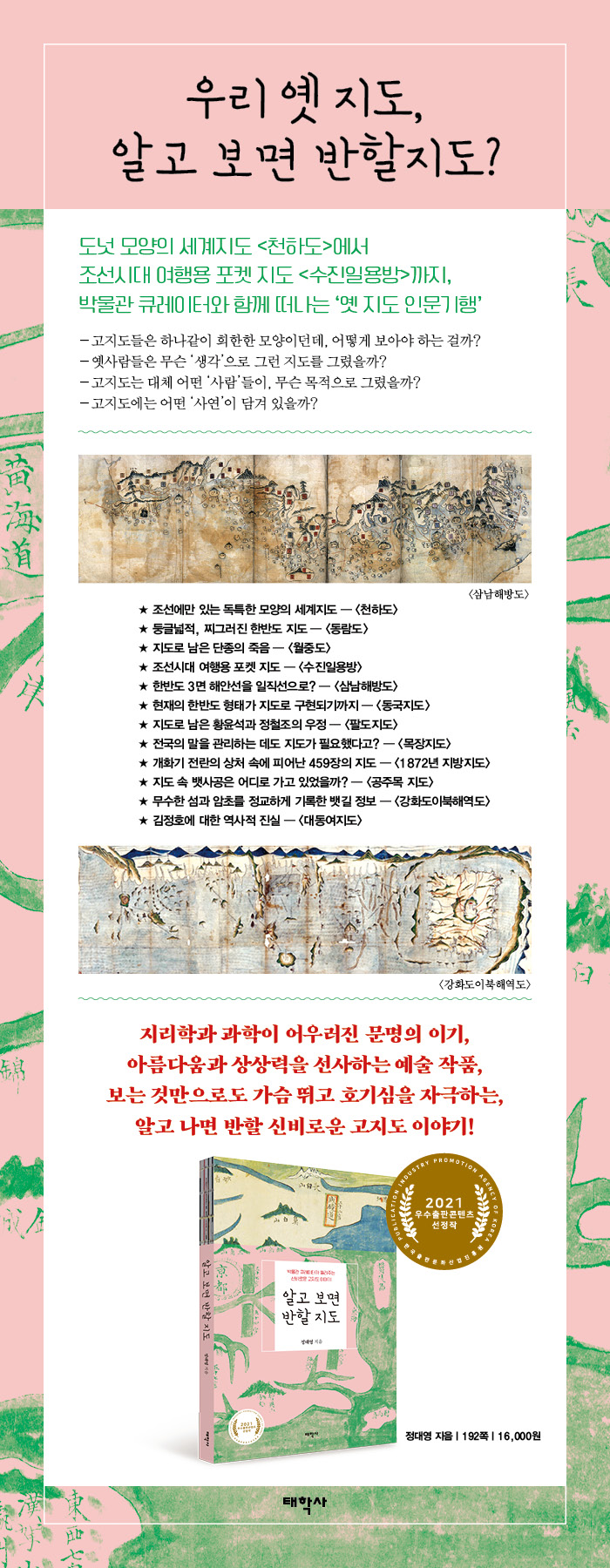
[Map of the Seas North of Ganghwa Island], a guide to countless islands and reefs.
Joseon transported most of its grain, collected as goods and taxes, to Hanyang via rivers and coastal sea routes.
However, the coast of the Korean Peninsula often has rapid tides or reefs, like Uldolmok, so even skilled sailors frequently encounter accidents. One of the places where maritime sinkings were frequent was near Ganghwa Island.
This area was a strategic military location, with large tidal ranges and many reefs, requiring a detailed map. The detailed map created for this purpose was Shin Gyeong-jun's [Map of the Sea North of Ganghwa Island].
This map contains detailed information about the reefs and shipping routes along the west coast north of Ganghwa Island.
In reality, it classifies the invisible reefs by type and details their depth, size, width, etc., and even records the name of each reef.
This map, which is nearly 3 meters in size, is believed to have been produced for military purposes, and it provides a good insight into how various types of information were recorded through the pictorial format of a map.
Reading stories through old maps, reading old maps through stories
In addition to this, this book contains various stories about old maps.
Through maps drawn for various purposes, such as [Dongramdo], which depicts the Korean Peninsula in a round and wide manner, [Wansanbujido], which depicts the scenery of Jeonju 150 years ago with pictorial beauty, [Woljungdo], which records the death of King Danjong and his historic sites, [Sujinilyongbang], which was a pocket map for travel for commoners in the Joseon Dynasty, and [Samnamhaebangdo], which draws the three coasts of the Korean Peninsula in a straight line, the author explains why people of the time drew such maps.
Meanwhile, the [Paldojido], which records the friendship between Hwang Yun-seok and Jeong Cheol-jo, the [Man-guk-jeon-do], a world map silently drawn by Ha Baek-won, Min Yeong-hwan's world tour, and the [Pasture Map], created to manage horses across the country, contain the lives and history of the people of the time.
Lastly, the author tells historical stories through old maps, including Kim Jeong-ho's [Cheonggudo], which depicts in detail the location of the Gyeon-a Sang-ip-jip and the menstrual period, [Mujang-hyeon Map of Jeolla-do], which depicts even a boatman rowing a boat along the river, [Sando (山圖)], which records ancestral graves, and the story of the discovery of the [Daedongyeojido] woodblock.
In 20 stories, readers will encounter what kind of 'thoughts' people had when drawing maps, what kind of 'people's' stories are contained in the maps, and what kind of historical 'stories' are contained in them.
A unique world map that remains only in Joseon, [Cheonhado]
This circular map consists of an innermost continent, another outer continent in the shape of a ring, and the inner and outer seas of each.
Here, several Asian place names such as Joseon, China, Japan, and Okinawa are confirmed, but there are also names of strange countries such as Ichimoku (一目國), where people with one eye live, Immortal Country (不死國), where people never die, and Laughing Country (小人國), where small people live.
This map was created after the Imjin War.
At that time, Joseon intellectuals, seeing the Ming Dynasty collapse and the barbarian Qing Dynasty unifying China, began to think that Joseon was the only "little China" that would succeed the vanished Ming Dynasty.
Society gradually became more conservative, and Confucianism also began to change.
Even though there were already scientific world maps created by Europeans at the time, Joseon Confucian scholars created their own new world by including the names of countries that appeared in Chinese literature, which were familiar to them, instead of countries they could not understand or needed to know.
Until the current shape of the Korean Peninsula was realized on a map, [Donggukjido]
When it comes to maps of the Korean Peninsula, the first thing that comes to mind is Kim Jeong-ho's [Daedongyeojido].
However, there was another person who played a decisive role in the creation of such a sophisticated map of the Korean Peninsula.
This is Jeong Sang-gi, a cartographer from the 18th century.
It is said that King Yeongjo could not help but admire the [Donggukjido] he drew, and the reason for this was the map-making method called 'Baekricheok'.
Baekricheok refers to a scale where 100 li on a map is reduced to 1 cheok, and Jeong Sang-gi achieved the innovative feat of drawing the entire country on 8 maps using the same scale as a standard.
This map was the most precise map of the Korean Peninsula at the time, and it marked a turning point in the development of small-scale maps in the late Joseon Dynasty.
A map that has reached the artistic level, [1872 Provincial Map]
Maps possess both geographical and artistic properties, but among old maps, there are some that are particularly outstanding in their artistic quality.
One of them is [1872 Provincial Map].
Daewongun, who had raised the banner of national isolation in the face of the incoming wave of enlightenment, ordered each local county to create and submit a geographical map for the purpose of strengthening military facilities across the country.
In this way, a total of 459 [1872 Provincial Maps] were created, including beautiful maps drawn with great care by local artists.
In particular, the map of Nakan County in Jeolla Province is superb with its modern sensibility, refreshing colors, and depiction of the region, which is the inherent value of a map. Looking at the map, which must have been created with a fervent heart during a national crisis, it seems to show the peak of the splendid culture of an old dynasty, like a flame emitting its last light before dying out.
[Map of the Seas North of Ganghwa Island], a guide to countless islands and reefs.
Joseon transported most of its grain, collected as goods and taxes, to Hanyang via rivers and coastal sea routes.
However, the coast of the Korean Peninsula often has rapid tides or reefs, like Uldolmok, so even skilled sailors frequently encounter accidents. One of the places where maritime sinkings were frequent was near Ganghwa Island.
This area was a strategic military location, with large tidal ranges and many reefs, requiring a detailed map. The detailed map created for this purpose was Shin Gyeong-jun's [Map of the Sea North of Ganghwa Island].
This map contains detailed information about the reefs and shipping routes along the west coast north of Ganghwa Island.
In reality, it classifies the invisible reefs by type and details their depth, size, width, etc., and even records the name of each reef.
This map, which is nearly 3 meters in size, is believed to have been produced for military purposes, and it provides a good insight into how various types of information were recorded through the pictorial format of a map.
Reading stories through old maps, reading old maps through stories
In addition to this, this book contains various stories about old maps.
Through maps drawn for various purposes, such as [Dongramdo], which depicts the Korean Peninsula in a round and wide manner, [Wansanbujido], which depicts the scenery of Jeonju 150 years ago with pictorial beauty, [Woljungdo], which records the death of King Danjong and his historic sites, [Sujinilyongbang], which was a pocket map for travel for commoners in the Joseon Dynasty, and [Samnamhaebangdo], which draws the three coasts of the Korean Peninsula in a straight line, the author explains why people of the time drew such maps.
Meanwhile, the [Paldojido], which records the friendship between Hwang Yun-seok and Jeong Cheol-jo, the [Man-guk-jeon-do], a world map silently drawn by Ha Baek-won, Min Yeong-hwan's world tour, and the [Pasture Map], created to manage horses across the country, contain the lives and history of the people of the time.
Lastly, the author tells historical stories through old maps, including Kim Jeong-ho's [Cheonggudo], which depicts in detail the location of the Gyeon-a Sang-ip-jip and the menstrual period, [Mujang-hyeon Map of Jeolla-do], which depicts even a boatman rowing a boat along the river, [Sando (山圖)], which records ancestral graves, and the story of the discovery of the [Daedongyeojido] woodblock.
GOODS SPECIFICS
- Publication date: November 30, 2021
- Page count, weight, size: 192 pages | 316g | 140*210*20mm
- ISBN13: 9791168100336
- ISBN10: 116810033X
You may also like
카테고리
korean


korean

![ELLE 엘르 스페셜 에디션 A형 : 12월 [2025]](http://librairie.coreenne.fr/cdn/shop/files/b8e27a3de6c9538896439686c6b0e8fb.jpg?v=1766436872&width=3840)


